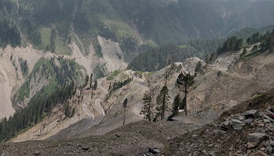
Image Source: Ashish Raina
About Mughal Road
The Mughal road is one of the most scenic and historically significant mountain routes in the region. It’s not just a roadway but a journey through time. Originally developed by the Mughal emperors as a royal passage to Kashmir, today it serves as an alternate and picturesque route connecting Jammu with the Kashmir valley.
Cultural and Spiritual Significance
The name Pir Panjal comes from the fusion of the words “Pir” (Sufi saint) and “Panjal” (five passes or mountains). The pass is particularly sacred due to the shrine of Sheikh Ahmed Karim, a revered Sufi saint, located right at the top of the pass. The shrine, known as Peer Ki Gali, attracts both Muslims and Hindus and is considered a place of spiritual tranquillity and miracles.
Geography of Mughal Road
The Mughal road cut across the Pir panjal range at Peer Ki Gali pass, located at about 11,500 feet (3,505 meters) above sea level. Passing through one of the major sub-ranges of the Himalayas, it begins from Bufliaz in the Poonch district (Jammu region) and ends at Shopian in the Kashmir Valley. The total length of the route is approximately 84km that covers terrain like Rugged, mountainous areas with alpine meadows, deep valleys, gorges, and pine forests
The southern slope of the Pir Panjal (towards Bufliaz and Poonch) is covered in oak, deodar, and fir forests.
The northern slope (towards Shopian) opens into vast meadows, glacial rivers, and cultivated lands near the Kashmir Valley.
River Systems
On the Jammu side, the road is influenced by the Poonch River system, which carves through deep gorges and valleys.
As one descends into Shopian, the landscape is shaped by the Rambiara River, a tributary of the Jhelum.
Climate Zones
The Mughal Road passes through three distinct climatic zones:
Subtropical (Poonch and Rajouri)—warm summers and mild winters.
Temperate (Hill Slopes and Meadows)—Cool summers, snowfall in winters.
Alpine (Peer Ki Gali and higher reaches)—harsh cold, heavy snowfall, high winds, and dramatic weather shifts.
Best time to visit
The best time to visit Mughal road is from May to October. Heavy snowfall in the upper reaches, particularly around Peer Ki Gali; the road remains closed for 4–5 months during winter (December to April).
History of Mughal Road
Kashmir came under the rule of Akbar in 1586. The Mughals thought of building a royal route from Delhi to Srinagar. The construction of the road started in Akbar but especially during Jahangir, the importance of the route increased manifold. Jahangir loved Kashmir so much that when he died in 1627 his body was carried through the Mughal road. He was buried near Rajouri and according to local legend, it’s believed that his heart and entrails were buried at Chingus Fort en route.
However, the importance of road decreased during Dogra rule and after post-independence, they remained neglected due to political and logistical challenges
It was revived and reconstructed in the early 2000s and officially opened for civilian use in 2009.
How to Reach the Mughal Road
From Jammu:
Drive to Rajouri → Thanamandi → Bufliaz → Mughal Road
The journey to Bufliaz from Jammu is approximately 230 km.
From Srinagar:
Travel to Pulwama → Shopian → Mughal Road
Distance from Srinagar to Shopian is about 60 km.
Local Transport Options
While self-driving is the most convenient option, local transport options are:
Sumo taxis and shared jeeps: Regularly available from Rajouri, Poonch, and Shopian.
Mini-buses: Operate between small towns on either end of the route.
Biking tours: Popular among adventure riders for the stunning terrain.
Note: Limited public transport runs on the higher sections like Peer Ki Gali. Always check road conditions before travel.
Important Places Along Mughal Road
Peer Ki Gali: The highest point and a spiritual place. Panoramic views and Sufi shrines make it a peaceful stop.
Bufliaz: The starting point in Jammu, a quaint town surrounded by pine forests.
Aliabad Sarai: A historical Mughal-era rest house built for caravans. Now in ruins but worth a visit.
Dubjan Meadows: Near Shopian, a peaceful area surrounded by fir and deodar trees.
Noori Chamb Waterfall: Named after Jahangir’s wife, Noor Jahan, this waterfall is a beautiful natural attraction.
Chingus Fort: Located near Rajouri, this fort contains the tomb of Emperor Jahangir’s entrails.
Shopian Town: Known for apple orchards and ancient shrines like Jamia Masjid and Aasar-e-Sharif Dargah.
Best Route to Travel Mughal Road
Recommended Scenic Route (From Jammu to Srinagar):
Jammu → Akhnoor → Rajouri → Thanamandi → Bufliaz → Peer Ki Gali → Shopian → Pulwama → Srinagar
This route offers a complete blend of historical forts, Mughal-era ruins, alpine meadows, and the thrill of mountain driving. It’s less commercialised compared to the Jammu–Srinagar highway and rich in natural beauty.
Unknown & Interesting Facts
Burial of Jahangir’s Organs: The emperor’s heart and intestines were buried in Chingus Fort to preserve his body for transport to Lahore.
Name origin: “Chingus” is Persian for intestines.
Aliabad Sarai is one of the last surviving Mughal caravanserais in the region.
Strategic road: Mughal Road is not just a tourism route; it’s crucial for military logistics in case the Jammu-Srinagar highway is blocked.
Wildlife Corridor: The road passes through the Hirpora Wildlife Sanctuary, home to the endangered Markhor goat and leopards.
Located at an altitude of 3,490 meters (11,450 feet), the Pir Panjal pass, also known as Peer Ki Gali, is a scenic mountain pass in the western Himalayas.
The pass forms a natural divide between the Kashmir valley and the Plains of Jammu. A historical route built during the Mughal era stands today as a key point on the restored Mughal road.
