Image Source: AshLin
About Ita Fort
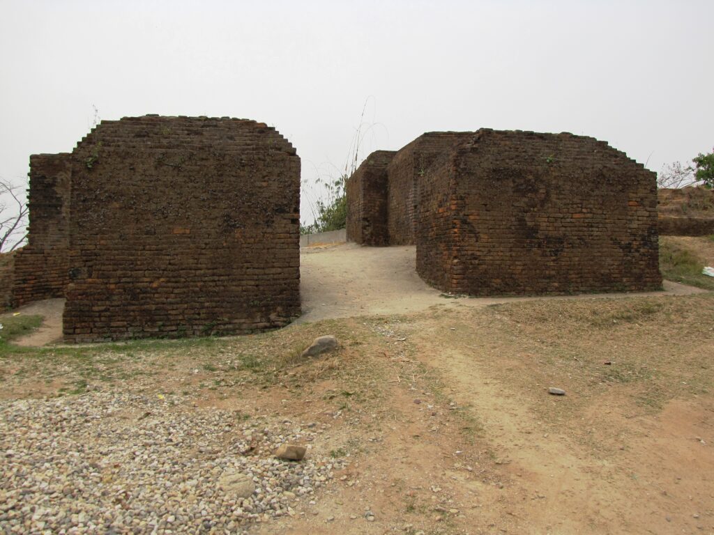
Standing quietly on a forested hill in the middle of Itanagar, Ita Fort is one of the oldest and most fascinating historical landmarks in Arunachal Pradesh. Surrounded today by the growing capital city, the fort still carries an air of mystery that connects visitors to the region’s medieval past. The word “Ita” comes from the Assamese language, meaning “brick.” Interestingly, despite the name, much of the structure was actually built using carefully cut stone blocks along with a large number of bricks.
Believed to have been constructed between the 14th and 15th centuries, Ita Fort is often associated with the Chutia dynasty, which once ruled parts of present-day Assam and Arunachal Pradesh before the rise of the Ahoms. Some historians and local traditions, however, suggest that the fort may have been built by a powerful tribal ruler who controlled the hill trade routes of the region. Even today, the exact story behind the fort remains partly unresolved, which only adds to its historical charm.
Located amidst green hills and bamboo groves, the fort offers not just a glimpse into history but also beautiful views of Itanagar and the surrounding valleys. For locals, Ita Fort is more than a monument — it is a symbol of the cultural roots of Arunachal Pradesh.
Historical Significance
The construction of Ita Fort is considered a remarkable engineering achievement, especially when one considers the rugged hilly terrain and the limited technology available at the time. Historians believe that nearly 80 lakh bricks, along with huge quantities of dressed stone, were transported and assembled to create the massive fortification. Such a large-scale project suggests the presence of an organized kingdom with access to skilled labor, planning, and resources.
The fort was strategically built on elevated ground, allowing those inside to monitor movement along important trade and communication routes connecting the Brahmaputra plains with the Himalayan foothills. These routes were historically important for trade, political control, and cultural exchange between tribal communities and the kingdoms of Assam.
Over centuries, Ita Fort has survived heavy monsoon rains, earthquakes, and thick vegetation growth. Much of its durability comes from the impressive interlocking stone construction technique used by the builders. The stones were fitted together so precisely that very little mortar was required. Though parts of the fort are now in ruins, the remaining walls and gateways still showcase the craftsmanship of medieval builders in Northeast India.
Architecture of Ita Fort
One of the most interesting features of Ita Fort is that its layout follows the natural contours of the hill rather than a perfectly symmetrical design. This helped strengthen the fort’s defenses while adapting to the uneven terrain.
Massive Stone Walls
The fort walls were constructed using large, finely dressed stone blocks combined with bricks in some sections. Even today, visitors can see how tightly the stones fit together without the heavy use of cement or lime mortar.
Three Main Gates
Ita Fort originally had several entrances, but three major gates still survive today:
- Eastern Gate – Considered the most decorative and architecturally detailed gate.
- Western Gate – Facing towards the plains and believed to have connected important routes.
- Southern Gate – Thought to be the principal entrance to the fort complex.
Each gate was protected by thick defensive walls and bastions designed to guard against attacks.
Height and Structure
The fort walls vary in height from around 1.5 meters to nearly 5 meters in some places. Certain sections are extremely thick, showing that the fort was built with military defense in mind.
Interior Remains
Although no royal palace or major building survives today, archaeological studies suggest that residential and administrative structures once existed within the enclosure. Interestingly, there are no major temple ruins or religious carvings inside the fort, indicating that Ita Fort mainly served as a military and administrative center rather than a religious site.
Local Culture and Surroundings
Ita Fort is deeply woven into the identity of Itanagar. During local festivals and state celebrations, the fort often becomes an important cultural backdrop. The surrounding area reflects the diverse tribal culture of Arunachal Pradesh, especially the traditions of the Nyishi community, one of the largest indigenous groups in the region.
Visitors exploring the fort can also experience the relaxed atmosphere of Itanagar city, where modern cafes, traditional markets, Buddhist gompas, and tribal heritage coexist. Nearby attractions include the Jawaharlal Nehru State Museum, Ganga Lake (Gyakar Sinyi), and the scenic hill viewpoints around the capital.
The monsoon season transforms the hills around Ita Fort into lush green landscapes, while winter offers pleasant weather and clearer views for sightseeing.
Best Time to Visit
The ideal time to visit Ita Fort is between October and April, when the weather remains cool and comfortable. Winters in Itanagar are mild compared to many Himalayan destinations, making sightseeing enjoyable.
The monsoon months from June to September bring heavy rainfall to the region. While the greenery becomes spectacular during this time, slippery pathways and dense vegetation can make exploration slightly difficult.
How to Reach Ita Fort
Ita Fort is centrally located in Itanagar and can easily be reached by taxi, auto-rickshaw, or private vehicle.
By Air
The nearest airport is Hollongi Airport, located about 15 km from Itanagar. The airport connects Arunachal Pradesh with major Indian cities such as Guwahati, Kolkata, and Delhi.
By Rail
The closest railway station is Naharlagun Railway Station, around 15 km away, with train services connecting the region to Guwahati and other northeastern cities.
By Road
Itanagar is well connected by NH-415. The city can be reached from:
- Guwahati – approximately 350 km
- Tezpur – approximately 200 km
- North Lakhimpur – around 60 km
Shared sumos, buses, and taxis regularly operate between Assam and Itanagar.
Visitor Information
Ita Fort is maintained by the Archaeological Survey of India (ASI). The site generally remains open from 9:00 AM to 5:00 PM.
Visitors are advised to wear comfortable footwear, especially during the rainy season, as the pathways around the fort can become slippery. Early morning and late afternoon are the best times to explore the site and enjoy the surrounding scenery.
Google Maps
FAQs
Why is Ita Fort famous?
Ita Fort is famous for being one of the oldest archaeological sites in Arunachal Pradesh. It is known for its massive stone walls, medieval architecture, and historical connection to ancient kingdoms of Northeast India.
Who built Ita Fort?
Most historians believe the fort was built by the Chutia dynasty during the 14th–15th century, although some local traditions attribute it to an independent tribal ruler.
What does the name “Ita” mean?
“Ita” means “brick” in Assamese. The fort received this name because large numbers of bricks were used during construction.
Is there an entry fee for Ita Fort?
Entry rules may change over time, but the site is generally accessible to visitors at minimal or no cost.
What is the best season to visit Ita Fort?
The best time to visit is from October to April when the weather is pleasant and ideal for sightseeing.
How much time is needed to explore the fort?
Most visitors spend around 1–2 hours exploring the fort, walking around the walls, and enjoying the surrounding views.
Are guides available at Ita Fort?
Local guides may occasionally be available, especially during tourist seasons, though many visitors prefer self-guided exploration.
What other attractions are nearby?
Nearby attractions include Ganga Lake, Jawaharlal Nehru State Museum, Indira Gandhi Park, and several Buddhist monasteries around Itanagar.


, How To Reach: Itanagar")