Image Source: Diganta Talukdar
About Kaziranga National Park
Kaziranga National Park is not just a forest with animals; it is a carefully shaped natural system built around the Brahmaputra River floodplain in Assam. Geographically, the park stretches like a long rectangle along the southern bank of the Brahmaputra, covering about 430 sq km of grasslands, wetlands, and semi-evergreen forests. The northern edge of Kaziranga is defined by the mighty river itself, while the southern boundary rises gradually into the Karbi Anglong Hills, creating a natural slope from low marshy plains to higher forested ground.
This slope is extremely important: during the annual monsoon floods, animals migrate from the submerged grasslands in the north toward the higher forested terrain in the south. The park’s terrain is therefore layered horizontally—riverine sandbars and tall elephant grass near the Brahmaputra, marshes and beels (wetlands) in the central belt, and wooded foothills in the south. This arrangement makes Kaziranga one of the richest wildlife habitats in Asia because grazing animals dominate the open floodplains, while predators and browsers prefer the wooded uplands. In simple terms, Kaziranga functions like a living corridor between river and hills, shaped every year by floodwaters that renew grasslands and prevent forest overgrowth.
Zonal Structure of Kaziranga – How the Park is Naturally Divided
For management and tourism, Kaziranga is divided into four main ranges (zones) that roughly correspond to different ecological characters.
The Western Range (Bagori) lies closest to the Brahmaputra and has extensive grasslands and shallow water bodies. This is the most open and wildlife-dense part of the park.
The Central Range (Kohora) forms the heart of Kaziranga and has a mixed landscape of grasslands, forest patches, and wetlands.
The Eastern Range (Agaratoli) is more remote, wetter, and marshier, with tall reeds and less tourist traffic.
The Burapahar Range lies toward the southwest, closer to Karbi Anglong, and is hilly and forested rather than grassy.
Each of these zones supports different animal concentrations because species choose habitats based on water, cover, and food type.
Main Entrances and What They Lead To
Kaziranga has multiple entry gates, each opening into a different ecological zone. The most commonly used entrance is Kohora Gate on the NH-37 highway, which leads directly into the Central Range. This is considered the park’s core tourism gateway because it provides balanced exposure to grassland animals and forest species. The Bagori Gate near Bokakhat leads into the Western Range and is famous for high visibility of large mammals. The Agaratoli Gate in the east connects visitors to the Eastern Range, which feels more wild and less disturbed. The Burapahar Gate accesses the hilly forest zone and is often associated with trekking and birding rather than jeep safaris. These entrances are not random—they correspond closely to the park’s ecological gradient from wet floodplain in the north and west to wooded upland in the south.
Animal Distribution by Zone
The Western Range (Bagori) is the best area for spotting one-horned rhinoceros, as the wide grasslands near the Brahmaputra provide ideal grazing. It is also excellent for seeing wild water buffalo, swamp deer (barasingha), and large herds of hog deer. Predators such as tigers are present but usually hidden in tall grass or forest edges.
In the Central Range (Kohora), the mixed terrain supports a wider variety of species. Here you are most likely to see elephants, rhinoceros, sambar deer, and sometimes sloth bears near wooded patches. The wetlands attract large numbers of migratory birds in winter, making this zone important for birdwatching.
The Eastern Range (Agaratoli) is more water-dominated, with reed beds and marshes. This makes it especially suitable for water birds, including pelicans, storks, and fishing eagles. It is also a stronghold for wild buffalo and grazing deer. Tigers exist here too, but sightings are rarer due to dense vegetation and fewer safari vehicles.
The Burapahar Range differs completely in character. It is drier, forested, and hilly, and therefore more suitable for leopards, hoolock gibbons, and forest birds rather than grazing animals. Large herbivores are fewer here because grasslands are limited, but the area is ecologically crucial as a refuge during floods.
How Geography Shapes Wildlife Experience
What makes Kaziranga unique is that geography directly controls animal movement. During dry months, animals spread across grasslands and wetlands. During floods, they instinctively move southward toward Burapahar and Karbi Anglong foothills. This seasonal rhythm means that wildlife sightings are not random but linked to terrain. Grasslands mean rhinos and buffalo, wetlands mean birds and deer, and forested slopes mean primates and carnivores. Visitors who understand this layout can predict what they are likely to see simply by knowing which gate they enter and which zone they explore.
If you want, I can next write a separate section on seasonal movement (monsoon vs winter) or make a simple map-style explanation in words (north–south and east–west layout) so readers visualize it instantly.
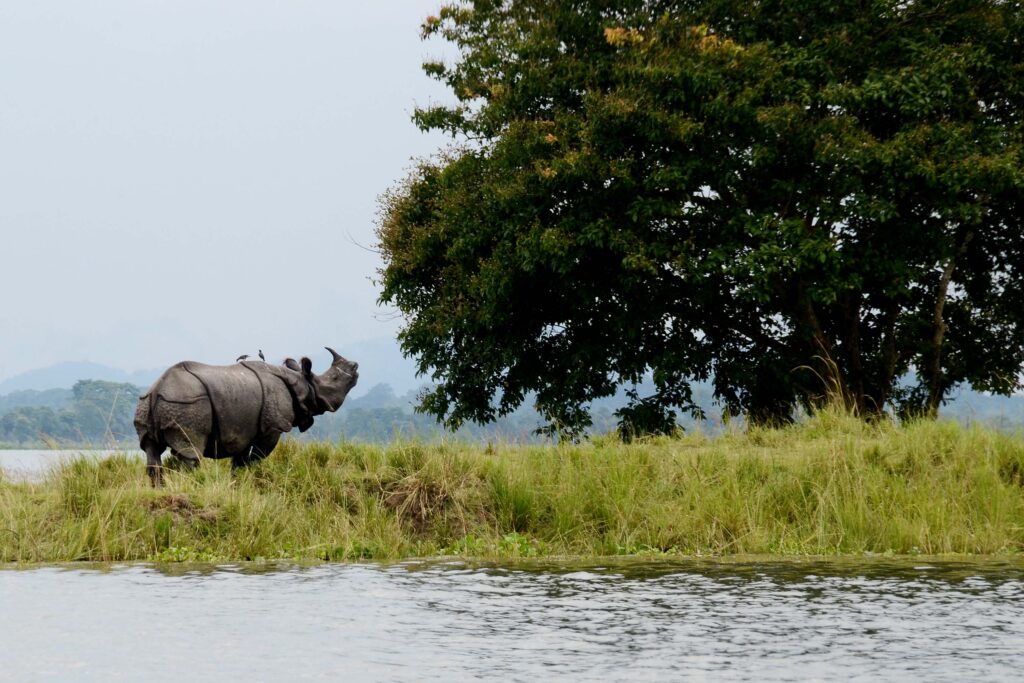
Floodplain Geography and Herbivore Concentration (Rhino, Buffalo, Deer)
Kaziranga’s western and central ranges lie on the active floodplain of the Brahmaputra, where annual monsoon floods deposit nutrient-rich alluvial soil. This soil supports the growth of tall elephant grass, cane brakes, and aquatic plants, which form the primary diet of large herbivores such as the one-horned rhinoceros, wild water buffalo, swamp deer, and hog deer. Rhinos, in particular, are highly dependent on soft grasses and submerged plants found near beels (oxbow lakes) and seasonally flooded meadows. Because these grasslands regenerate rapidly after floods, they act as permanent grazing grounds. As a result, herbivores naturally cluster in the flatter western and central sectors of the park where forage availability is highest and visibility is good enough to detect predators.
Wetlands and Avifaunal Zones (Water Birds, Otters, Reptiles)
The northern and eastern parts of Kaziranga are shaped by river channels, marshes, and flood-created wetlands, forming a mosaic of shallow lakes and reed beds. These aquatic systems sustain fish populations, amphibians, and aquatic vegetation, which attract migratory waterfowl, storks, pelicans, and fish eagles during winter. Otters also concentrate here because of the high density of fish and slow-moving water bodies. Reptiles such as turtles and water snakes depend on these warm, shallow pools for thermoregulation and breeding. The wetland belt thus becomes a specialized ecological zone where food chains are built around water rather than grass, explaining why bird diversity is highest in the eastern range near Agoratoli.
Grass–Forest Transition and Predator Presence (Tiger and Leopard)
Large carnivores such as the Bengal tiger and leopard are most frequently recorded in areas where tall grasslands merge with woodland and semi-evergreen forests, particularly in the eastern and central sectors. These transition zones provide both prey availability and concealment. Tall grasses allow tigers to stalk grazing herbivores like hog deer and wild buffalo calves, while forest patches provide shade, resting sites, and secure denning areas. Predators avoid fully open grasslands because they offer little ambush cover, and they avoid deep wetlands because movement is difficult. Therefore, their preferred habitat lies between the herbivore plains and forest interiors, where ecological edges create optimal hunting conditions.
Southern Uplands and Arboreal Species (Gibbons, Langurs, Elephants)
The Burapahar range, located toward the southern boundary near the Karbi Anglong hills, differs geographically from the floodplain because it is elevated and less prone to inundation. This region supports semi-evergreen and deciduous forests, which are structurally complex with tall trees and layered canopies. Such vegetation is essential for arboreal primates like the hoolock gibbon and capped langur, which depend on continuous tree cover for brachiation and fruit-based diets. Elephants also use this southern forest belt as a seasonal refuge during floods, moving upslope to avoid rising waters. This explains why primate sightings and forest mammals are concentrated in the Burapahar sector rather than in the open plains.
Seasonal Flooding and Animal Movement Patterns
Annual monsoon flooding acts as a natural regulator of animal distribution within Kaziranga. When water levels rise, grazing animals such as rhinos, deer, and buffalo migrate temporarily toward the higher chapories (raised islands) and the southern uplands. Once floodwaters recede, they return to the nutrient-rich grasslands. Predators follow these herbivore movements, shifting their territories accordingly. Birds respond differently; winter migrants arrive when wetlands stabilize after floods, using exposed mudflats and shallow waters for feeding. Thus, animal presence in specific zones is not static but rhythmically linked to the park’s hydrological cycle.
Ecological Zonation as a Survival Strategy
The overall distribution of wildlife in Kaziranga reflects a system of ecological specialization rather than competition. Herbivores dominate grasslands because of food abundance, predators occupy transitional zones because of hunting efficiency, birds concentrate near wetlands due to aquatic prey, and primates remain in upland forests due to arboreal needs. This spatial separation reduces interspecies conflict and allows high biodiversity within a relatively compact landscape. In effect, Kaziranga functions as a layered ecological corridor, where each geographic belt supports a distinct biological community shaped by water, vegetation, and elevation.


