Image Source: Ravi Aparanji
About Pushpagiri Peak
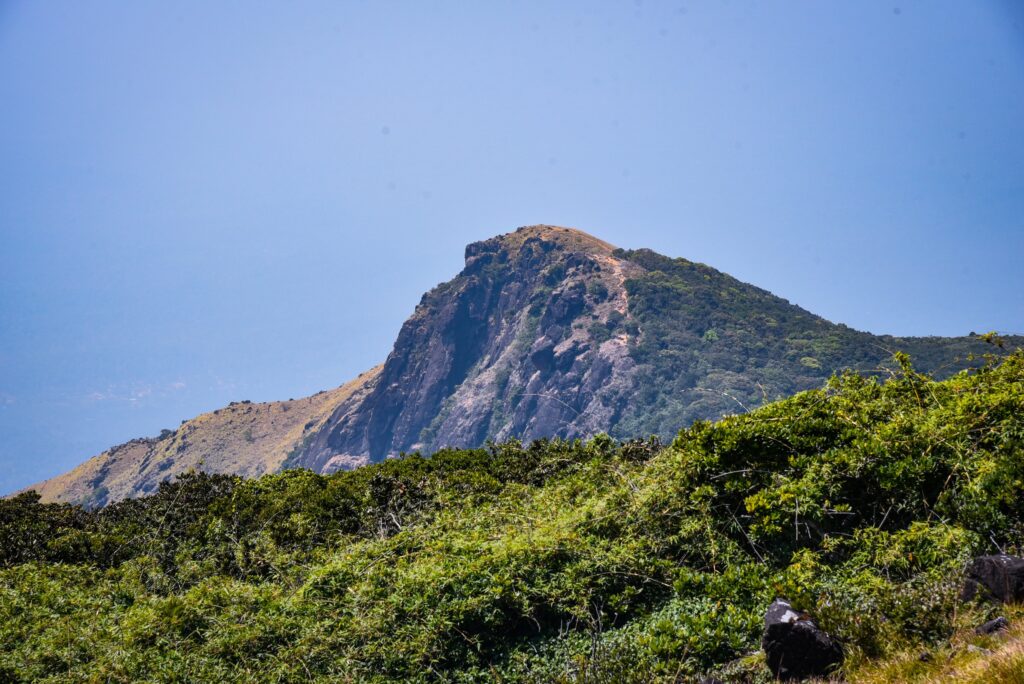
Hidden amidst the mist-covered landscapes of Coorg, Pushpagiri Peak is one of the most rewarding trekking destinations in Karnataka. Located within the lush Pushpagiri Wildlife Sanctuary, this majestic peak rises to an elevation of about 5,626 feet (1,715 meters), making it the sixth-highest peak in the state and the second-highest in Coorg after Thadiyandamol.
The trek is famous for its breathtaking scenery, dense evergreen forests, rolling grasslands, and panoramic views of the Western Ghats. Pushpagiri is also ecologically significant, as it serves as the origin of the Harangi River, one of the important tributaries in the region. The sanctuary surrounding the peak is home to a rich variety of birds, butterflies, and wildlife, making it a paradise for nature lovers and photographers.
Whether you are seeking adventure, solitude, or stunning mountain views, Pushpagiri offers an unforgettable experience in the heart of Coorg’s wilderness.
Trekking Expedition to Pushpagiri Peak
The trek to Pushpagiri Peak is approximately 7 kilometers one way and is generally considered moderately challenging. Most trekkers begin their journey from the forest checkpoint near Heggademane Village. After obtaining the necessary entry permission, the trail gradually leads through thick forests, bamboo groves, rocky stretches, and expansive grasslands.
As you gain altitude, the views become increasingly spectacular. During clear weather, trekkers can enjoy sweeping vistas of the surrounding hills and valleys that stretch across the Western Ghats.
One of the highlights of the trek is the small Kumara Swamy Temple situated near the summit. Many visitors pause here to seek blessings and enjoy a moment of peace before taking in the magnificent views from the peak. The combination of natural beauty and spiritual significance makes the trek particularly memorable.
The best time to visit is between October and February when the weather is pleasant and the visibility is excellent. The post-monsoon months also transform the landscape into a lush green paradise.
Extended Adventure: Kumara Parvatha and Girigadde
For adventure enthusiasts looking for a longer expedition, Pushpagiri can be combined with a trek towards Kumara Parvatha, one of Karnataka’s most famous trekking peaks.
After crossing Pushpagiri, trekkers can continue towards Girigadde, a scenic camping area located roughly 7 kilometers away. The campsite offers basic accommodation facilities and serves as a resting point for those undertaking longer trekking routes.
From Girigadde, the trail eventually connects towards Kukke Subramanya. The journey from Girigadde to Kukke covers another 7 kilometers and typically takes around three to four hours, depending on fitness levels and trail conditions. This extended route offers a more immersive experience of the Western Ghats and is popular among seasoned trekkers.
Tips for Trekkers
Before starting the trek, it is important to be well-prepared, as weather conditions in the Western Ghats can change rapidly.
- Carry sufficient drinking water and energy snacks.
- Wear sturdy trekking shoes with good grip.
- Pack a raincoat or poncho, especially during the monsoon and post-monsoon seasons.
- Leeches are common in the sanctuary, particularly during the rainy months. Carry salt, anti-leech socks, or leech-repellent powder.
- Start the trek early in the morning to avoid trekking after dark.
- Follow forest department guidelines and avoid littering within the sanctuary.
- Mobile network coverage can be limited in some sections of the trail.
Entry Fee and Camping
Visitors are required to pay an entry fee at the forest check post before beginning the trek. The fee has traditionally been around ₹75 per person, although charges may change periodically. Additional fees may apply for camping or overnight stays. It is advisable to confirm the latest charges with local authorities before visiting.
How to Reach Pushpagiri Peak
Pushpagiri Peak is located in the northern part of Coorg district and can be accessed through Heggademane Village near Somwarpet.
By Air
The nearest airport is Mangalore International Airport, located about 140 km away. From the airport, taxis and buses are available to reach Somwarpet and nearby trekking access points.
By Train
The closest major railway stations are Mysuru Railway Station and Mangalore Railway Station. From either station, visitors can hire a taxi or take a bus to Somwarpet.
By Road
Pushpagiri is well connected by road from major Karnataka cities.
- Madikeri to Pushpagiri Base: Approximately 35 km
- Somwarpet to Pushpagiri Base: Approximately 20 km
- Mysuru to Pushpagiri Base: Approximately 135 km
- Bengaluru to Pushpagiri Base: Approximately 260 km
Private vehicles are the most convenient option, although KSRTC and private buses operate regularly to Somwarpet from Bengaluru, Mysuru, and Mangalore.
Nearby Attractions
Mallalli Falls
One of Coorg’s most spectacular waterfalls, Mallalli Falls cascades dramatically from a great height amidst dense greenery. It is especially beautiful during and after the monsoon season.
Kumaralli Viewpoint
A scenic viewpoint offering panoramic views of the surrounding mountains, valleys, and coffee plantations.
Honnamana Kere
The largest natural lake in Coorg, Honnamana Kere is associated with local legends and is surrounded by peaceful natural scenery.
Madikeri Fort
A historic fort in Madikeri showcasing the region’s rich history, architecture, and cultural heritage.
Raja’s Seat
One of Coorg’s most popular viewpoints, Raja’s Seat offers stunning sunrise and sunset views over the rolling hills of the Western Ghats.
Harangi Dam
Built across the Harangi River, this picturesque dam is a popular picnic spot and offers beautiful views during the monsoon season.
Maps
Situated at a distance of 70 km from Madikeri and 33 km from Somvarpet, Pushpagiri emerges as a majestic mountain peak within the Kodagu district of Karnataka.
FAQs
1. Is Pushpagiri Peak suitable for beginners?
Yes, the trek is moderately difficult and can be completed by beginners with a reasonable level of fitness.
2. What is the height of Pushpagiri Peak?
Pushpagiri Peak stands at approximately 5,626 feet (1,715 meters) above sea level.
3. How long does the trek take?
Most trekkers take around 4–6 hours for the ascent and descent, depending on pace and weather conditions.
4. Is prior permission required for trekking?
Yes, visitors must register and pay the entry fee at the forest check post before starting the trek.
5. What is the best season for the trek?
October to February is considered the best time due to pleasant weather and clear views.
6. Are leeches common on the trail?
Yes, leeches are common during the monsoon and post-monsoon months.
7. Can camping be done near Pushpagiri?
Camping is permitted only in designated areas and may require additional permissions and fees.
8. Is Pushpagiri part of a wildlife sanctuary?
Yes, the peak is located within the Pushpagiri Wildlife Sanctuary, known for its rich biodiversity.
9. Are guides available for the trek?
Local guides can be arranged from nearby villages and are recommended for first-time visitors.
10. Can Pushpagiri and Kumara Parvatha be covered in a single trek?
Experienced trekkers sometimes combine both routes, but it requires proper planning, fitness, and adequate time.


