Image Source: Abhishek Gaurav
About Bailey Trail Trek
The Bailey Trail Trek in Arunachal Pradesh isn’t just another Himalayan adventure—it’s a journey that beautifully mixes raw natural beauty with fascinating history. Named after British explorers Frederick Marshman Bailey and Henry Tyndale Morshead, this trail traces a route they mapped in the early 1900s.
Back in 1911–1912, Bailey and Morshead were tasked with surveying the remote frontier between India and Tibet—then known as the North-East Frontier Agency (NEFA). Their expedition took them along the dangerous stretches of the Yarlung Tsangpo, reaching deep into Tibetan regions like Chayul and Tsona Dzong.
On their return, they crossed back into India through the high-altitude Tulung La Pass. From there, they navigated through remote villages, icy passes, and rugged terrain—eventually creating what we now know as the Bailey Trail. Today, it stands as one of the most offbeat and historically rich treks in the Eastern Himalayas.
Trek Route & Experience
This trek is as much about the journey as the destination. It typically begins from Dirang, where trekkers prepare before heading to Lagaam—the starting point of the trail.
The initial days ease you into the trek with scenic walks through meadows and forests, including Thungri, where you’ll spot old wartime bunkers quietly blending into the landscape.
As you climb higher, places like Changla Top (3,760 m) greet you with stunning views and, in spring, slopes covered in colorful rhododendrons. A small alpine lake near the pass adds to the magic.
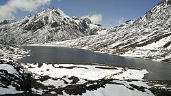
The trail then gets more demanding as you cross high passes like Porshing La and Pangi La. Eventually, you reach one of the highest points—Tche La (over 4,500 m), where a pristine glacial lake sits quietly amidst dramatic mountain scenery.
Descending from here, the landscape slowly softens as you pass ITBP camps and reach the remote village of Mago. A night here offers a glimpse into simple mountain life, often in basic but warm guesthouses.
The final stretch takes you by road toward Tawang, crossing the breathtaking Sela Pass, often blanketed in snow.
Cultural & Historical Highlights
Monpa Culture
Along the trail, you’ll come across Monpa villages, where life moves at a slower pace. Their traditions, food, and architecture reflect a deep connection to Tibetan Buddhism.
Echoes of History
Scattered along the route are old bunkers, mule tracks, and supply paths—remnants of Allied activity during World War II. These silent relics add a unique historical layer to the trek.
Rich Biodiversity
The trail passes through dense rhododendron forests, alpine meadows, and high-altitude ecosystems. It’s a paradise for nature lovers, with chances to spot rare birds and unique Himalayan flora.
How to Reach
By Air:
The nearest airport is Tezpur Airport, about 190 km from Dirang.
By Train:
The closest railway station is Rangapara North Railway Station.
By Road:
Dirang is well connected by road from places like Bomdila and Tezpur, with buses and shared taxis available.
Best Time to Visit
Spring (April–June):
Perfect if you want to see rhododendrons in full bloom and enjoy pleasant weather.
Autumn (September–November):
Clear skies, stable conditions, and the best mountain views.
Winter:
Possible, but only for experienced trekkers due to heavy snowfall and extreme conditions at high passes.
FAQs
1. How difficult is the Bailey Trail Trek?
It’s a challenging trek with high-altitude passes and long walking days, best suited for experienced trekkers.
2. Do I need special permits?
Yes, Arunachal Pradesh requires Inner Line Permits (ILP) for Indian travelers and Protected Area Permits (PAP) for foreigners.
3. Is altitude sickness a concern?
Yes, since the trek goes above 4,500 meters, proper acclimatization is essential.
4. Are guides necessary for this trek?
Highly recommended. The trail is remote and not well-marked, so local guides are important for navigation and safety.
5. What kind of accommodation is available?
Expect basic camping and simple guesthouses in villages like Mago.
6. Is the trek suitable for beginners?
Not really. It’s better suited for those with prior high-altitude trekking experience.
7. What makes this trek unique?
Its blend of untouched Himalayan landscapes, rich Monpa culture, and historical significance from early exploration and wartime history makes it truly special.