Image Source: Yogesh K Gupta
About Satpula Bridge
Hidden amid the urban landscape of South Delhi, Satpula Bridge is one of the city’s most fascinating yet overlooked historical structures. Located near Saket, this 14th-century monument is far more than just an old bridge—it is an extraordinary example of medieval engineering that combined transportation, water conservation, and flood control into a single structure.
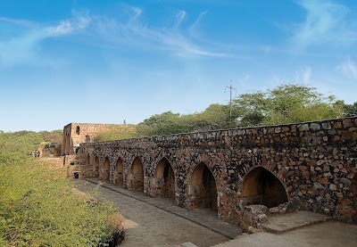
The name “Satpula” literally translates to “Seven Bridges” or “Seven Arches,” referring to the seven massive arched openings that form the core of the structure. Built during the rule of the Tughlaq dynasty, Satpula once played a crucial role in managing Delhi’s water resources while also connecting important settlements of the Sultanate period. Even today, the monument quietly reflects the practical brilliance of medieval Indian architecture.
History
Satpula Bridge is believed to have been constructed during the reign of Sultan Muhammad bin Tughlaq between 1325 and 1351 AD. The Tughlaq rulers were known for their ambitious construction projects, particularly those related to urban planning, fortifications, reservoirs, and road networks.
During the 14th century, Delhi was expanding rapidly, and the growing population created increasing pressure on water resources. Seasonal streams flowing from the Aravalli hills often flooded during the monsoon and dried up during summer. To solve this issue, the Tughlaq administration developed sophisticated water-management systems, and Satpula became one of the most important among them.
The bridge was built across a natural water channel that carried rainwater toward the Yamuna River. Instead of allowing the monsoon water to flow away unused, the structure acted like a dam and sluice-gate system, helping store and regulate water for nearby agricultural lands and settlements. This stored water supported villages and habitations that later evolved into areas around present-day Saket, Khirki, and Malviya Nagar.
Apart from water management, Satpula also served as an important communication link between the medieval cities of Siri and Jahanpanah. This dual-purpose design perfectly illustrates the Tughlaq approach to architecture—functional, durable, and strategically planned.
Architecture and Engineering Design
Satpula Bridge is regarded as one of the earliest examples of a dam-bridge hybrid in the Indian subcontinent. Unlike decorative Mughal monuments built centuries later, Satpula was designed with practicality in mind.
Seven Arched Openings
The most striking feature of the monument is its seven large arches, which gave the bridge its name. These arches allowed water to pass through while maintaining structural stability. During heavy monsoon flow, the openings helped distribute water pressure evenly across the structure.
Two-Storeyed Construction
The bridge was designed with two levels of arches. This clever arrangement allowed engineers to regulate water flow according to seasonal changes. During periods of intense rainfall, excess water could pass through the upper and lower openings, reducing the risk of flooding.
Advanced Water-Control System
Satpula was not merely a crossing point. Stone slabs could be inserted into parts of the arches to control or block water flow. In effect, the bridge functioned like a medieval barrage or sluice gate. This demonstrates the advanced understanding of hydraulic engineering possessed by Sultanate architects.
Rubble Masonry and Lime Mortar
The structure was built using rubble masonry combined with lime mortar, materials widely used during the Tughlaq period. The thick stone walls were designed to withstand strong water pressure and survive for centuries. Even in its partially ruined condition today, the monument still reflects remarkable structural strength.
Causeway and Walkway
The upper portion of the bridge served as a roadway and pedestrian path. During dry seasons, carts, travelers, and animals could cross easily from one side to the other. This combination of transport infrastructure and water engineering was highly innovative for its time.
Importance of Satpula in Medieval Delhi
Satpula Bridge offers valuable insight into how medieval Delhi functioned beyond its palaces and forts. It reveals that rulers of the Delhi Sultanate invested heavily in practical infrastructure essential for sustaining urban life.
The monument symbolizes:
- The engineering innovation of the Tughlaq dynasty.
- Medieval India’s understanding of water conservation techniques.
- The importance of sustainable infrastructure in growing cities.
- The integration of transportation and hydraulic systems.
Unlike monuments built purely for grandeur, Satpula represents architecture designed to solve real-world problems. In many ways, it was centuries ahead of its time.
Present Condition of Satpula Bridge
Today, Satpula stands quietly amid modern residential neighborhoods and urban development in South Delhi. Although parts of the structure have deteriorated over time, several arches and walls remain intact. The surrounding water channels have largely disappeared due to urbanization, making it difficult for visitors to imagine the monument’s original hydraulic function.
Despite its historical significance, Satpula often receives fewer visitors compared to more famous Delhi monuments like Qutub Minar or Humayun’s Tomb. However, for history enthusiasts, photographers, architects, and students of engineering, it remains an incredibly rewarding site to explore.
Best Time to Visit
The ideal time to visit Satpula Bridge is during the cooler months between October and March. Early mornings and late afternoons are especially pleasant, as the soft sunlight enhances the texture of the old stone structure.
The post-monsoon season is particularly interesting because traces of water flow around the bridge become more visible, helping visitors better understand its original purpose.
How to Reach Satpula Bridge
By Metro
The nearest metro stations are Delhi Metro Yellow Line stations at Saket and Malviya Nagar. From either station, the bridge can be reached by auto-rickshaw, taxi, or a short local commute.
By Road
Satpula is well connected through Press Enclave Road and Aurobindo Marg. Private vehicles and taxis can easily access the site from most parts of Delhi.
By Rail
Hazrat Nizamuddin Railway Station is located around 8 km away from the monument.
Nearby Historical Attractions
Visitors interested in Delhi Sultanate architecture can combine Satpula with several nearby medieval monuments in South Delhi.
Khirki Masjid
Khirki Masjid is a unique fortified mosque known for its enclosed courtyard and distinctive window openings.
Bijay Mandal is believed to have been part of Muhammad bin Tughlaq’s palace complex and offers panoramic views of the surrounding area.
Begumpur Mosque
Begumpur Mosque is one of the largest and most impressive mosques built during the Tughlaq period.
Chor Minar
Chor Minar is a striking tower associated with Alauddin Khalji’s rule and local legends involving thieves and punishment.
Hauz Khas Complex
Hauz Khas Complex combines a medieval reservoir, mosque, madrasa, and tombs, showcasing the sophisticated water systems of medieval Delhi.
Visitor Information
- Entry Fee: Free.
- Timings: Open during daylight hours.
- Photography: Allowed.
- Best Duration: 30 minutes to 1 hour.
- Ideal For: History lovers, photographers, architecture students, heritage walks.
Google Maps
FAQs
Why is Satpula Bridge called “Satpula”?
The name comes from the seven arches built into the structure. “Sat” means seven, and “pula” refers to a bridge.
Who built Satpula Bridge?
The bridge was built during the reign of Muhammad bin Tughlaq in the 14th century.
What was the purpose of Satpula Bridge?
Satpula served both as a bridge and a water-control structure. It regulated monsoon water flow, stored water for irrigation, and connected nearby settlements.
Is Satpula Bridge still functional today?
The bridge no longer performs its original hydraulic role because the surrounding water channels have changed due to urban development. However, the monument still stands as an important historical structure.
What makes Satpula architecturally unique?
Its combination of transportation infrastructure and hydraulic engineering makes it one of the earliest known dam-bridge hybrids in India.
Is Satpula Bridge worth visiting?
Yes, especially for people interested in Delhi’s medieval history, Sultanate architecture, and ancient engineering systems. It offers a quieter and less crowded heritage experience compared to Delhi’s major tourist sites.
Which metro station is closest to Satpula Bridge?
Saket and Malviya Nagar metro stations on the Yellow Line are the closest options.


