Image Source: Harjinder Anoopgarh
About Jalsu Pass trek
The Bharmour-Baijnath Across Jalsu Pass trek is characterized as an easy, three-day journey, with its highest elevation at 3600 meters (m). The ideal trekking season for this route spans from May to November .
Jalsu pass located at an elevation of 3600 meters, is one of the most accessible passes in the Dhauladhar range. Connecting Bharmour on the upper river valley and Baijnath on the Kangra side, the trek is easy and moderate.
It is frequently used by locals and shepherds when other more challenging treks like Thamsar pass is closed. It opens early in the season, allowing those accustomed to snow-walking. The ideal trekking season for this route spans from May to November.
The trek typically begins from Holi, a picturesque sub-valley located 36 kilometers from Bharmour. Holi is an administrative sub-tehsil with a small bazaar and government guest houses for accommodation. It also features a trout fish farm.
The trek can be broken down into the following stages:
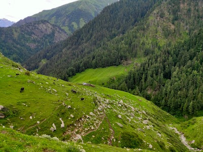
Holi to Yara (8-10 hours)
Nayagram can be covered by a motor road that is located 12 kilometers from Holi. Regular bus services and taxis are available from Holi. At Nayagram there is ample space for pitching a tent near the school or along the road.
From Nayagram, a well-defined path leads to the Laka Mata Temple , a site of great local reverence, which also has a small sarai for pilgrims. Women seeking blessings often stay here for days.
The trail then descends steeply to a wooden bridge over a nallah (stream), a point locally known as patal puri (hell).
Following this, a sharp climb leads to Surahi village , referred to as swarg puri (heaven). Surahi is a small village with a primary school and forest guard hut, offering a good camping site.
The trek to Jalsu Pass continues from below Surahi village at a comfortable gradient. Seasonal tea shops may operate between June and October.
The path descends to cross another nallah via a wooden bridge, then climbs gradually towards Yara. This climb can be tiring on sunny days due to water scarcity on the trail. A forest hut is visible from a distance, though it is often bug-infested due to use by shepherds. A few dhabas (roadside eateries) also appear during summers, but good campsites are limited near them.
It is possible to reach Jalsu ka Paddar (plain of Jalsu) by evening with an early start from Nayagram. Jalsu ka Paddar is a good camping spot, but trekkers should carry firewood from Yara as it is not available there. Dhabas offer basic necessities, and Gujars and Gaddis camping there might sell milk and butter.
Jalsu ka Paddar to Baijnath (8-10 hours)
Jalsu Pass is visible from Jalsu ka Paddar, but start early in the morning, as it’s a long journey to Baijnath.
An easy ascent of about an hour takes trekkers to the top of the pass.
Two options are available for descent: a mule trek or traversing the right-side ridge.
The mule path is somewhat longer but clearly defined, involving several stream crossings that lack bridges or temporary crossings (tarangris).
The ridge route is preferred by locals during the rainy season when water levels rise, posing a risk on the mule path.
Both paths converge at Uttarala, a quiet village at the foothills of the Dhauladhar. Uttarala has a State Electricity Board rest house and a small bazaar, with regular bus and taxi services to Baijnath.
Google Maps