Image Source: Kiranraj
About Ayyanakere Lake
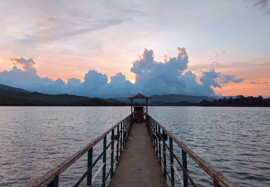
Ayyanakere Lake, the largest lake in Chikmagalur and the second-largest lake in Karnataka, offers an excellent opportunity to explore and enjoy the natural landscape. Embraced by the eastern end of the Baba Budan Range Hills, the lake offers a serene retreat with mountains enveloping three sides. The Ayyanakere Lake is part of the Krishna Basin that features 10 canals. Water from the lake irrigates around 1,560 hectares of agricultural land.
Geographical Setting
Ayyanakere lies in the Malenadu–Deccan transition zone, where the Western Ghats descend into rolling plains. The lake receives monsoon runoff from the Bababudangiri and Mullayanagiri hill slopes, making it a rain-fed reservoir deeply connected to the region’s topography. The surrounding landscape consists of open agricultural fields, gentle hillocks, and distant forested ridges, creating a natural basin that allows rainwater to collect and spread gradually rather than flow away rapidly.
Meaning of the Name and Sacred Associations
The name “Ayyanakere” is derived from “Ayyana,” a local guardian deity, and “kere,” meaning “lake” in Kannada. This naming reflects a traditional belief system in which water bodies were regarded as sacred entities protected by village gods. Ritual offerings and seasonal observances linked to agricultural cycles reinforced a sense of collective responsibility toward maintaining the lake, preventing overuse or neglect.
Religious Presence
Rukmangaday Raya, a ruler of Sakharayapatna, is believed to have constructed Ayyanakere Lake. In 1156 AD, it underwent further renovation during Hoysala’s rule. From ancient times, the water of Ayyanakere Lake helped in the water management and agriculture practices of the region.
Showcasing Hoysala-style sculptures, there is a town surrounding the lake featuring the Prasanna Balleshwara shrine dedicated to Lord Shiva. Ranganatha Swamy Temple is another noteworthy religious site in the vicinity.
Role in Traditional Irrigation Systems
For centuries, Ayyanakere functioned as a primary irrigation source for surrounding villages. Water from the lake was distributed through kaluvés (traditional canals) that fed paddy fields, vegetable plots, and later areca nut plantations. This system supported multiple cropping cycles and reduced dependence on unpredictable rainfall, making Ayyanakere central to food security in the region.
Ecological Importance and Biodiversity
Beyond agriculture, Ayyanakere Lake supports a diverse wetland ecosystem. Seasonal water fluctuations create habitats for aquatic plants, fish, frogs, and migratory birds. The lake also contributes to groundwater recharge, benefiting wells and bore sources in nearby villages. Its presence moderates local temperatures and enhances soil moisture, reinforcing the ecological stability of the Chikkamagaluru plains.
Ayyanakere and the Coffee Landscape of Chikkamagaluru
Although coffee plantations dominate the hill slopes of Chikkamagaluru, lakes like Ayyanakere have historically supported the lowland agrarian base that complements plantation economies. Paddy cultivation around the lake ensured a food supply for estate labor and local markets, highlighting the interdependence between the Malenadu highlands and plains.
Present Condition and Conservation Concerns
Today, Ayyanakere continues to function as an irrigation lake, but it faces challenges such as siltation, catchment degradation, and changing rainfall patterns. Reduced community involvement and increased dependence on borewells have altered traditional water management practices. However, awareness of the lake’s heritage and ecological value has renewed interest in its conservation and restoration.
Nearby Attractions at Ayyanakere Lake
Mullayanagiri Peak: The highest peak in Karnataka is located 20 km away from the lake. It’s also a popular trekking destination.
Baba Budangiri: This scenic and religiously important place is located 30 km away from the lake.
Coffee Plantations: Chikmagalur is famous for its coffee estates. Various guided tours offer to tell you about the process of coffee.
Bhadra Wildlife Sanctuary: The wildlife sanctuary is home to diverse flora and fauna. It’s easily accessible from the lake and located 35 km away.
Activities at Ayyanakaere lake
Photography: Captivating sunrise and sunset views in the background of conical-shaped Shakunagiri, reaching 4,600 feet, offer an excellent opportunity for photographers.
Fishing and Camping: Fishing and camping are multiple recreational activities where visitors can engage and spend quality time around the lake.
Trekking: Multiple treks pass through Shakungairi Hill that provide opportunities for exploring around the region.
Practical Information
Entry: Entry to the Ayyanakere Lake is free, allowing visitors to immerse themselves in nature.
Google Maps Ayyanakere Lake
Situated 5 km from Sakharayapatna, 63 km from Chikmagalur
FAQS
- Q: Where is Ayyanakere Lake located?
Ayyanakere Lake is located near Chikkamagaluru town, at the foothills of the Bababudangiri range in Karnataka. It lies close to villages like Sakharayapatna road belt, forming a major water body in the Malenadu–Deccan transition zone.
- Q: Who built Ayyanakere Lake?
Ayyanakere Lake was originally constructed during the Hoysala period, traditionally attributed to Rajaraja Hoysala in the 12th century. It is one of the oldest and largest man-made irrigation tanks in the Chikkamagaluru region.
- Q: Why is Ayyanakere Lake historically important?
The lake played a crucial role in agrarian water management for early Chikkamagaluru settlements. It supported paddy cultivation and village life long before modern dams, forming part of a Hoysala-era tank irrigation network.
- Q: What does the name “Ayyanakere” mean?
“Ayyana” refers to a local guardian deity or village god, while “kere” means lake in Kannada. The name reflects the traditional belief that the lake is protected by a presiding deity, reinforcing its sacred–ecological role.
- Q: How large is Ayyanakere Lake?
Ayyanakere is considered the largest lake in Chikkamagaluru district, covering a vast catchment area and capable of holding monsoon runoff from the surrounding hill slopes.
- Q: What rivers or streams feed Ayyanakere Lake?
The lake is primarily fed by monsoon streams descending from the Bababudangiri hills, making it a key rain-fed reservoir in the region.
- Q: What role does Ayyanakere play in local agriculture?
The lake historically irrigated large tracts of farmland through traditional canals (kaluvés), sustaining paddy fields and later supporting areca nut and other Malenadu crops.
- Q: Is Ayyanakere Lake still used today?
Yes, Ayyanakere continues to function as an important irrigation source, though its role has evolved alongside modern water systems.
- Q: What kind of landscape surrounds Ayyanakere Lake?
The lake is surrounded by open farmlands, gentle hillocks, and distant forested slopes, offering views typical of the coffee-growing belt of Chikkamagaluru.
- Q: Are there religious or cultural associations with the lake?
Yes, local rituals and village festivals traditionally acknowledged the lake as a life-giving and sacred resource, with offerings made to the guardian deity during key agricultural seasons.
- Q: Is Ayyanakere Lake a tourist spot?
While not commercialized, the lake attracts nature lovers, photographers, and heritage enthusiasts seeking quiet landscapes rather than urban recreation.
- Q: What is the best time to visit Ayyanakere Lake?
The best time is post-monsoon (September to February) when water levels are high and the surrounding fields are green.
- Q: Are there any environmental concerns related to Ayyanakere Lake?
Siltation, encroachment, and changing rainfall patterns pose challenges, making lake rejuvenation and catchment protection important for its survival.
- Q: How is Ayyanakere different from other lakes in Karnataka?
Unlike urban lakes, Ayyanakere is a functional heritage tank, deeply integrated with rural irrigation, history, and landscape ecology.
- Q: Is Ayyanakere Lake protected as a heritage site?
While historically significant, it is not formally developed as a heritage monument, relying largely on local stewardship and government irrigation management.