Image Source: Timothy A. Gonsalves.
About the Kabini River
The Kabini River, also known as the Kapila River, is one of the most beautiful and ecologically important rivers in southern India. Flowing through the scenic landscapes of Kerala and Karnataka, the river is admired for its rich biodiversity, cultural significance, and thriving wildlife habitats. Over the years, Kabini has become more than just a river — it is now one of India’s most celebrated eco-tourism destinations, attracting wildlife enthusiasts, photographers, birdwatchers, and nature lovers from across the world.
Surrounded by dense forests, rolling hills, and peaceful backwaters, the Kabini region offers a rare combination of natural beauty and wilderness. The river supports agriculture, provides drinking water to major cities, and sustains one of the richest forest ecosystems in the country.
Origin and Course of the Kabini River
The Kabini River is one of the major tributaries of the Cauvery River. It originates in the Wayanad region of Kerala, where several streams and rivers merge amid the lush Western Ghats. The river is mainly formed by the confluence of the Panamaram River and the Mananthavady River. Its waters are also fed by streams flowing from the Pakramthalam Hills along the Kuttiady–Mananthavady route.
From Kerala, the river flows eastward into Karnataka, passing through forests, agricultural lands, and wildlife-rich zones before finally merging with the Cauvery River. Along its journey, the Kabini receives water from several tributaries, including the Makkiyad, Periya, Kalindi, Taraka, and Nugu rivers.
One of the most fascinating natural formations along the river is Kuruva Island, a lush river island formed shortly after the Kabini meets the Panamaram River. Spread across nearly 520 acres, the island is famous for its dense greenery, bamboo groves, medicinal plants, and unique birdlife.
Kabini Dam and Reservoir
A major landmark associated with the river is the Kabini Dam, built in 1974 near Beechanahally village in Karnataka’s Mysuru region. Constructed across the Kabini River, the dam plays a crucial role in irrigation, drinking water supply, and water management across southern India.
The dam stretches approximately 696 meters in length and rises around 166 feet above the riverbed. Its vast reservoir stores enormous quantities of water and supports nearby agricultural regions during dry seasons.
The Kabini Reservoir is especially important because it supplies drinking water to cities such as Mysuru and Bengaluru. It also irrigates farmland spread across numerous villages and helps regulate water flow toward the Mettur Reservoir in Tamil Nadu.
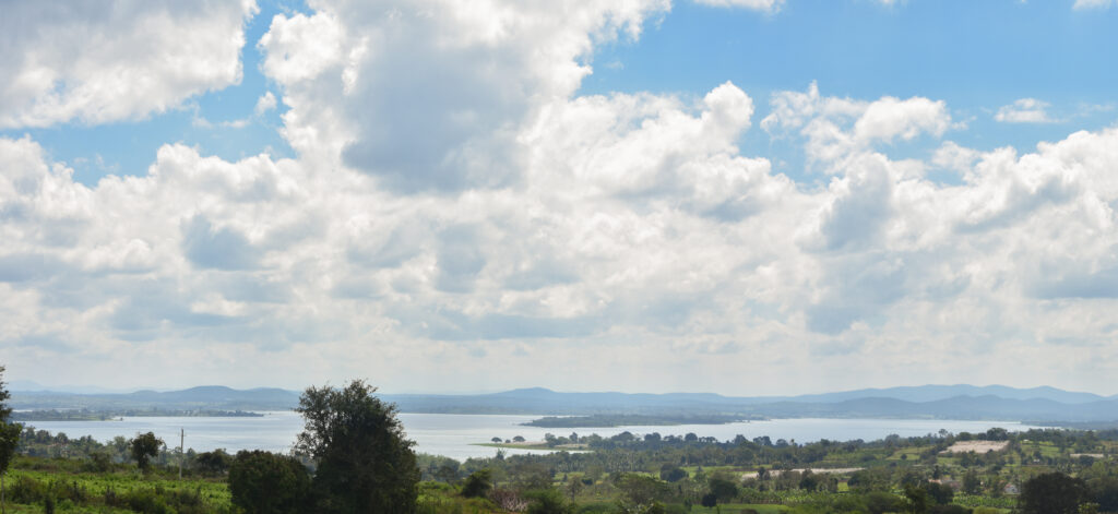
Beyond its practical importance, the reservoir has transformed the surrounding landscape into a spectacular eco-tourism zone. During sunrise and sunset, the still waters of Kabini reflect the forests and grasslands, creating breathtaking scenery that draws travelers throughout the year.
Wildlife and Forest Ecosystem
The Kabini region is globally renowned for its incredible wildlife population. The river and its backwaters form an essential part of the forest ecosystem connected to Nagarahole National Park, one of India’s premier tiger reserves.
During summer, the water level in the reservoir recedes, exposing vast stretches of grassy land along the riverbanks. These grasslands attract large herds of animals searching for water and fresh grazing grounds, making Kabini one of the best wildlife-viewing destinations in India.
The forests around Kabini are home to:
- Tigers and leopards
- Large herds of Asian elephants
- Indian gaurs and wild dogs
- Sloth bears
- Spotted deer, sambar deer, barking deer, and mouse deer
- Hundreds of resident and migratory bird species
Kabini is particularly famous for sightings of black panthers, which have occasionally been photographed in the forests of Nagarahole. Wildlife safaris in this region are considered among the finest jungle experiences in India.
Historically, the forests of Kabini served as royal hunting grounds for the Maharajas of Mysore and British officials during colonial times. Today, the area is carefully protected and managed as an important conservation landscape.
Kabini Bridge: A Historical Landmark
Another notable feature of the region is the historic Kabini Bridge, which spans the river and holds heritage value. The bridge reflects the engineering and transport history of the region and continues to serve local communities while adding to Kabini’s old-world charm.
Tourism Around Kabini
Today, Kabini has emerged as one of the top nature tourism destinations in southern India. Travelers visit the region not only for wildlife safaris but also for its peaceful environment and scenic beauty.
Some of the most popular experiences in Kabini include:
Wildlife Safaris
Jeep and boat safaris through Nagarahole forests offer visitors a chance to spot animals in their natural habitat. Early morning and evening safaris are particularly rewarding.
Boat Rides on the Backwaters
Boat rides across the calm Kabini backwaters provide stunning views of forests, marshlands, and wildlife gathering near the shoreline.
Bird Watching
Kabini is a paradise for birdwatchers. Eagles, kingfishers, herons, storks, owls, hornbills, and migratory water birds can often be seen around the riverbanks and wetlands.
Nature Photography
The dramatic landscapes, misty mornings, golden sunsets, and abundance of wildlife make Kabini a dream destination for photographers.
Jungle Resorts and Eco Lodges
The area around Kabini is dotted with eco-resorts and jungle lodges that offer immersive stays amidst nature. Many accommodations organize safaris, guided walks, and cultural experiences for visitors.
Best Time to Visit Kabini
The ideal time to visit Kabini depends on the kind of experience travelers are looking for.
- October to February: Pleasant weather and lush green landscapes make this the best season for general tourism and birdwatching.
- March to May: Excellent for wildlife sightings, as animals gather around the shrinking water bodies.
- June to September: The monsoon season transforms Kabini into a vibrant green paradise, though safaris may occasionally be affected by heavy rain.
Nearby Attractions of the Kabini River
The Kabini River is one of South India’s most scenic rivers, flowing through dense forests, wildlife habitats, and picturesque backwaters. The river is especially famous for its rich biodiversity and its association with the Kabini wildlife region. Visitors exploring the river can also discover several remarkable attractions nearby.
1. Nagarhole National Park
Located along the southern banks of the Kabini River, Nagarhole is one of India’s premier tiger reserves. The park is renowned for its tiger population, leopards, elephants, gaurs, and hundreds of bird species. Jeep safaris and boat safaris offer excellent opportunities to observe wildlife in their natural habitat.
2. Kabini Dam
Built across the Kabini River in 1974, the dam creates a vast reservoir surrounded by beautiful landscapes. It is a popular spot for photography, birdwatching, and enjoying sunset views over the backwaters.
3. Balle Elephant Camp
This elephant camp provides visitors with insights into elephant conservation and management. It is known for housing elephants associated with the famous Mysuru Dasara celebrations.
4. Bheemanakolli Mahadeshwara Temple
An ancient Shiva temple believed to be over 800 years old. Surrounded by forests and accessible through scenic routes, the temple offers a blend of spirituality and natural beauty.
5. Kuruva Island
Situated upstream on the Kabini River, Kuruva Island is a protected riverine island known for its bamboo groves, dense forests, and unique ecosystem. Nature walks and bamboo raft rides are popular activities here.
6. Bandipur National Park
Located a short drive from Kabini, Bandipur forms part of the Nilgiri Biosphere Reserve. The park is famous for tiger sightings, elephant herds, and scenic forest drives.
7. Wayanad Wildlife Sanctuary
Connected ecologically with the Kabini-Nagarhole landscape, this sanctuary is home to elephants, deer, leopards, and diverse birdlife, making it a favorite destination for nature enthusiasts.
8. Kabini Backwaters
The expansive backwaters formed by the Kabini Reservoir are among the most picturesque areas in the region. During summer, receding waters create lush grasslands that attract large herds of elephants and other wildlife.
9. Thirunelli Temple
An ancient temple nestled in the Brahmagiri Hills, revered for its spiritual significance and tranquil surroundings. It is often combined with visits to the upper reaches of the Kabini basin.
10. Dubare Elephant Camp
Located on the banks of the Kaveri River, Dubare offers elephant interaction programs, nature walks, and river-based activities. It can be visited as part of a broader wildlife circuit around Kabini.
Ecological Importance of the Kabini River
The Kabini River is much more than a scenic waterway. It plays a critical role in maintaining the ecological balance of the Western Ghats and the forests of southern India. The river supports agriculture, groundwater recharge, forest ecosystems, and countless species of wildlife.
Its wetlands and forests act as carbon sinks, while the river itself sustains both rural livelihoods and urban populations. Conservation efforts around Kabini are therefore essential not only for wildlife protection but also for long-term environmental sustainability.
Conclusion
The Kabini River beautifully represents the harmony between nature, wildlife, and human life. From its origins in the forests of Kerala to the wildlife-rich plains of Karnataka, the river flows through landscapes filled with history, biodiversity, and natural beauty.
Whether someone visits Kabini for thrilling tiger safaris, peaceful boat rides, birdwatching, or simply to experience the tranquility of the forests, the region leaves a lasting impression. Its combination of wilderness, scenic charm, and ecological significance makes Kabini one of the most treasured natural destinations in India.
Google Maps
FAQs
Where is the Kabini River located?
The Kabini River flows through the states of Kerala and Karnataka in southern India before joining the Cauvery River.
Why is Kabini famous?
Kabini is famous for its wildlife safaris, dense forests, elephant herds, tiger sightings, and beautiful backwaters connected to Nagarahole National Park.
Which national park is associated with Kabini?
Kabini is closely associated with Nagarahole National Park, one of India’s leading tiger reserves.
What is the best time to visit Kabini?
The best time to visit is from October to May. Summer months are especially good for wildlife sightings.
Is Kabini good for birdwatching?
Yes, Kabini is an excellent birdwatching destination with numerous resident and migratory bird species found near the river and wetlands.
How far is Kabini from Bengaluru and Mysuru?
Kabini is located around 205 km from Bengaluru and approximately 60 km from Mysuru.
What activities can tourists enjoy in Kabini?
Visitors can enjoy jeep safaris, boat safaris, birdwatching, nature photography, forest stays, and guided nature walks.
What is Kuruva Island?
Kuruva Island is a protected river island on the Kabini River known for its dense forests, bamboo groves, and unique ecosystem.


