Image Source: Suvan tijo
About Vembanad Lake
Vembanad Lake is one of the most remarkable natural treasures of Kerala and an integral part of the state’s famous backwater landscape. Stretching across several districts, this vast lake is not only the longest lake in India but also the largest lake in Kerala. More than just a scenic destination, Vembanad supports local livelihoods, agriculture, fishing communities, inland transport, tourism, and an incredibly rich ecosystem.
Spread across the heart of central Kerala, the lake forms a beautiful network of waterways, lagoons, canals, and wetlands that have shaped the culture and economy of the region for centuries. Depending on the area, the lake is known by different local names. In Kottayam and nearby regions, it is commonly called Vembanad Lake, while in Alappuzha and Kuttanad it is referred to as Punnamada Lake. Around Kochi, many people know it as Kochi Lake.
The global ecological significance of the lake was officially recognized in 2002 when the Vembanad-Kol Wetland system was declared a Ramsar Wetland of International Importance. It is the largest among Kerala’s Ramsar wetlands and is also protected under India’s National Wetlands Conservation Programme because of its environmental importance and role in sustaining thousands of people.
Geography and Physical Features
Vembanad Lake is enormous in scale and forms one of the most extensive wetland ecosystems in India. The lake stretches for nearly 96 kilometers and, at certain points, reaches a width of around 14 kilometers. Covering an area of more than 2,000 square kilometers, it spreads across the districts of Alappuzha, Kottayam, and Ernakulam.
Despite its vastness, the lake is relatively shallow, with a maximum depth of around 12 meters. Its shallow nature allows sunlight to penetrate easily, making the waters biologically productive and ideal for fish breeding and wetland vegetation.
One of the most fascinating aspects of the lake is its connection to Kerala’s river systems. Ten rivers drain into Vembanad, including some of Kerala’s most important rivers such as the Periyar River, Pamba River, Meenachil River, and Muvattupuzha River. These rivers bring freshwater, nutrients, and sediments into the wetland before eventually flowing into the Arabian Sea through a network of canals and estuaries.
The lake is separated from the Arabian Sea by narrow coastal strips and barrier islands, creating the calm backwater environment for which Kerala is famous. Numerous islands are scattered throughout the lake, adding to its beauty and ecological diversity. Among the best known are Pathiramanal Island, Perumbalam Island, and Vypin Island.
Kuttanad – The Rice Bowl of Kerala
The southern region of Vembanad Lake includes the famous Kuttanad, often called the “Rice Bowl of Kerala.” This region is globally unique because farming is carried out below sea level. Massive paddy fields protected by embankments lie lower than the surrounding water level, creating a landscape unlike anywhere else in India.
Farmers in Kuttanad have developed ingenious agricultural systems over generations to cultivate rice in these low-lying wetlands. The fertile alluvial soil deposited by rivers makes the region highly productive, and the area plays a crucial role in Kerala’s food production.
A major structure connected with this agricultural landscape is the Thanneermukkom Bund, also known as the Thanneermukkom Salt Water Barrier. Built under the Kuttanad Development Scheme, the barrier prevents seawater from entering the freshwater regions during the dry season. This allows farmers to cultivate additional crops by reducing soil salinity.
However, while the barrier benefits agriculture, it has also altered the natural balance of the wetland ecosystem by dividing the lake into freshwater and brackish water zones.
Ecological Importance of Vembanad
Ecologically, Vembanad Lake is among the most valuable wetlands in India. The wetland system supports a wide variety of fish, prawns, crustaceans, aquatic plants, migratory birds, and mangrove species. It acts as a breeding ground for shrimp and fish species that are important to Kerala’s fishing economy.
The lake is also one of India’s largest habitats for water birds. Every year, thousands of migratory birds arrive here during the winter season, transforming the wetlands into a paradise for birdwatchers and nature photographers.
On the northern side of the lake lies the famous Kumarakom Bird Sanctuary, where visitors can spot herons, egrets, kingfishers, darters, and migratory species from distant regions. The wetlands and mangroves around the lake also help regulate floods, store carbon naturally, and protect coastal ecosystems from erosion.
In many ways, Vembanad functions as Kerala’s environmental safety net. It absorbs excess monsoon water, supports fisheries, moderates local climate conditions, and sustains countless rural communities that depend on its resources.
Tourism and Backwater Experiences
Vembanad Lake is one of the biggest attractions in Kerala’s tourism industry. The lake forms the heart of the state’s globally famous backwater tourism circuit and attracts travelers from across India and around the world.
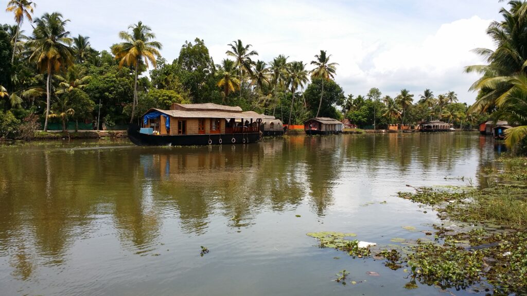
The most iconic experience here is cruising through the backwaters on traditional Kerala houseboats, locally known as kettuvallams. Once used to transport rice and spices, many of these boats have now been converted into luxurious floating hotels equipped with bedrooms, dining spaces, and viewing decks.
The scenic village of Kumarakom along the lake’s eastern shores is especially popular among tourists. Known for its peaceful environment, Ayurvedic resorts, coconut groves, and birdlife, Kumarakom offers a relaxing escape into Kerala’s rural beauty.
Another major attraction associated with the lake is the famous Nehru Trophy Boat Race, held annually on the waters of Punnamada Lake. During this spectacular event, long snake boats carrying dozens of rowers race through the backwaters amid cheering crowds, music, and festive celebrations. It is considered one of Kerala’s most iconic cultural events.
The lake’s islands, sunsets, fishing villages, and narrow canals together create a uniquely serene atmosphere that defines Kerala’s backwater charm.
Inland Water Transport and Connectivity
Apart from tourism, Vembanad has historically served as an important inland transport route. Before the development of modern roads, boats were the primary means of transportation for many villages around the lake.
Even today, ferries and country boats remain essential for local travel and trade. The lake is connected to an extensive canal network that links towns, villages, farms, and markets across the region.
The West Coast Canal passes through the Vembanad wetland system and forms part of India’s National Waterway network. This waterway has improved cargo movement and regional connectivity while preserving Kerala’s traditional relationship with water transport.
Environmental Challenges Facing the Lake
Despite its beauty and ecological importance, Vembanad Lake faces serious environmental threats. Pollution from industries, untreated sewage, plastic waste, and agricultural runoff has significantly affected water quality over the years.
Large-scale land reclamation has also reduced the size of the lake dramatically. Wetlands have been converted into agricultural land, residential areas, and infrastructure projects, leading to habitat loss and ecological imbalance. The expansion of areas around Kochi, including the development of Willingdon Island, has contributed to the shrinking of the original wetland area.
Another major concern is the spread of invasive aquatic plants such as water hyacinth. These plants block sunlight, reduce oxygen levels in the water, and affect fish populations. The altered water flow caused by the Thanneermukkom Barrier has further worsened weed growth and disrupted fish migration patterns.
Climate change, rising sea levels, and increasing urbanization also pose long-term risks to the fragile wetland ecosystem. Environmentalists and local communities continue to advocate for stronger conservation measures to protect this priceless natural heritage.
Cultural Significance
Vembanad Lake is deeply woven into the cultural identity of Kerala. Life along its shores revolves around fishing, farming, boat-building, coir-making, and traditional water transport. Many folk songs, local festivals, and culinary traditions of Kerala are closely connected to the backwaters.
The lake has also inspired writers, filmmakers, photographers, and artists for generations. From peaceful village life to dramatic monsoon landscapes, Vembanad represents the essence of Kerala’s relationship with water and nature.
Best Time to Visit Vembanad Lake
The ideal time to visit Vembanad Lake is between October and March, when the weather remains pleasant and suitable for houseboat cruises, birdwatching, and sightseeing. The monsoon season from June to September transforms the backwaters into lush green landscapes, though heavy rains may affect travel plans.
August is particularly lively because of the snake boat race season, which attracts huge crowds and creates a festive atmosphere across the backwaters.
How to Reach Vembanad Lake
Located in the heart of Kerala’s famous backwater region, Vembanad Lake stretches across the districts of Kottayam, Alappuzha (Alleppey), and Ernakulam. The most popular access points for tourists are Kumarakom and Alappuzha. The lake is well connected by air, rail, and road, making it easy to visit from anywhere in Kerala.
By Air:
The nearest airport is Cochin International Airport, located about 75–80 km from Kumarakom. Taxis and airport transfer services are readily available for reaching the lake area.
By Train:
The nearest major railway station is Kottayam Railway Station, approximately 14–16 km from Kumarakom and the eastern shores of Vembanad Lake. Auto-rickshaws, taxis, and local buses are available from the station.
By Road:
Kumarakom and Alappuzha are well connected to major Kerala cities such as Kochi, Kottayam, and Thiruvananthapuram through state highways. Regular KSRTC and private buses operate to these destinations. Visitors can also hire taxis or self-drive to the lake.
By Water:
One of the most scenic ways to experience Vembanad Lake is through traditional houseboats and shikara boats operating from Kumarakom and Alappuzha jetties, offering a memorable journey through Kerala’s backwaters.
Nearby Attractions
Kumarakom Bird Sanctuary
Situated on the eastern banks of Vembanad Lake, this renowned bird sanctuary attracts migratory birds such as herons, egrets, kingfishers, and Siberian visitors during winter. It is a paradise for birdwatchers and nature photographers.
Pathiramanal Island
A beautiful island located in the middle of Vembanad Lake, Pathiramanal is accessible only by boat. The island is known for its rich birdlife, peaceful atmosphere, and picturesque backwater scenery.
Kumarakom
This charming backwater village is famous for luxury resorts, houseboat cruises, coconut groves, and stunning lake views. It serves as one of the main gateways to Vembanad Lake.
Kuttanad
Known as the “Rice Bowl of Kerala,” Kuttanad is famous for its below-sea-level paddy fields, scenic waterways, and traditional village life. A boat ride through this region offers an authentic backwater experience.
Punnamada Lake
A part of the Vembanad wetland system, Punnamada Lake is famous for hosting the annual Nehru Trophy Snake Boat Race, one of Kerala’s most celebrated cultural events.
Alappuzha Beach
Located a short drive from the lake, this popular beach features a historic pier, lighthouse views, and beautiful sunsets over the Arabian Sea.
Kakkathuruthu Island
Often called the “Island of Crows,” this tranquil island in Vembanad Lake is known for spectacular sunsets, canoe rides, and traditional fishing village life.
Thanneermukkom Bund
An engineering landmark built across Vembanad Lake, this saltwater barrier separates freshwater and brackish water zones and offers scenic views of the surrounding wetlands.
Google Maps
FAQs
1. Why is Vembanad Lake famous?
Vembanad Lake is famous for being the longest lake in India, Kerala’s largest lake, and the centerpiece of the state’s backwater tourism. It is also known for houseboat cruises, birdlife, wetlands, and snake boat races.
2. Which districts does Vembanad Lake cover?
The lake spreads across several districts of Kerala, mainly Alappuzha, Kottayam, and Ernakulam.
3. What is special about Kuttanad near Vembanad Lake?
Kuttanad is unique because farming is done below sea level. It is one of the few places in the world where below-sea-level paddy cultivation is practiced.
4. What is the Thanneermukkom Bund?
The Thanneermukkom Bund is a saltwater barrier built across the lake to prevent seawater intrusion into agricultural fields in Kuttanad.
5. Which birds can be seen around Vembanad Lake?
Visitors can spot herons, egrets, kingfishers, cormorants, darters, and several migratory bird species, especially around Kumarakom Bird Sanctuary.
6. What activities can tourists enjoy at Vembanad Lake?
Tourists can enjoy houseboat cruises, birdwatching, village tours, canoe rides, fishing experiences, sunset viewing, and cultural festivals like snake boat races.
7. Is Vembanad Lake a Ramsar Site?
Yes, the Vembanad-Kol Wetland system was designated as a Ramsar Wetland of International Importance in 2002.
8. What are the major environmental problems affecting the lake?
Pollution, land reclamation, invasive weeds, declining fish populations, and ecological imbalance caused by human activities are some of the major environmental concerns affecting the lake.


