Image Source: Dr Karamat Ali
About the Shingo River
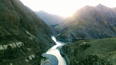
The Shingo River flows through one of the most rugged and sensitive landscapes in the Himalayas, near the India–Pakistan border in Ladakh. Rising in the mountainous region of Baltistan, the river travels toward the Kargil district, carving its way through high-altitude terrain before eventually merging with larger river systems.
Remote, stark, and largely untouched, the Shingo River is not just a geographical feature—it’s also deeply tied to the region’s history, ecology, and strategic importance.
Geographical Overview
The river begins its journey in the Chota Deosai plains near Minimarg. From here, it flows eastward through mountainous terrain, passing through areas like Domel and gathering strength from smaller streams and glacial meltwaters.
Along its route, the Shingo is joined by tributaries such as the Dras River and the Burzil stream. After crossing the historic Burzil Pass, it enters Indian territory near the village of Karkit.
Within India, the river flows for a relatively short distance before rejoining the Dras River near Lushut, close to the Line of Control (LoC). Eventually, its waters feed into the Suru River, which is a major tributary of the Indus River.
Overall, the Shingo River stretches roughly 100–150 km, with most of its course lying in Pakistan-administered territory.
Tributaries
The Shingo River is sustained by several streams and snow-fed channels, including:
- Burzil Nala (originating near Burzil Pass)
- Dras River (joins near Lushut)
- Numerous smaller glacial streams and seasonal meltwater channels
These tributaries play a crucial role in maintaining the river’s flow, especially in such a cold and arid region.
Location Near the Line of Control (LoC)
A significant portion of the Shingo River flows close to the Line of Control, the de facto boundary between India and Pakistan. In certain stretches, the river acts as a natural geographic divider between Indian-administered Ladakh and Pakistan-administered Gilgit-Baltistan.
Because of its proximity to the LoC, the river and its valley are not just geographically important but also politically and strategically sensitive.
Historical Importance of Burzil Pass
The nearby Burzil Pass once served as an important trade route connecting Srinagar with Gilgit. Before the partition of India in 1947, traders, caravans, and even British survey teams regularly used this route.
Today, however, the passage is no longer accessible due to the militarization of the region and the presence of the LoC.
Strategic Significance
The Shingo River valley lies close to the sensitive Kargil sector, which witnessed intense fighting during the Kargil War.
The surrounding areas—Minimarg, Burzil, Karkit, and Dras—form a narrow corridor where control over mountain passes and ridgelines is critical. Both India and Pakistan maintain a strong military presence here, monitoring movement and securing their respective positions.
Military Relevance
Due to its terrain and location:
- The valley is used for logistical movement and supply routes in high-altitude conditions
- Military posts on both sides closely monitor the river and surrounding ridges
- The area plays a key role in maintaining surveillance along the LoC
This makes the Shingo River not just a natural feature, but an important element in regional security dynamics.
Environment & Ecology
Despite its strategic importance, the Shingo River flows through a fragile and fascinating ecosystem. The region is characterized by cold desert conditions, sparse vegetation, and extreme weather.
Key ecological features include:
- Alpine meadows in higher altitudes near Deosai and Burzil
- Snow-fed streams that sustain the river year-round
- Wildlife such as Himalayan ibex, marmots, and even elusive snow leopards in higher reaches
Because of its remoteness, the area remains largely untouched by industrial development. However, climate change and expanding infrastructure pose growing concerns for this delicate environment.
How to Reach Shingo River
By Air
The nearest airports are:
- Srinagar International Airport – approximately 220–230 km from Drass.
- Kushok Bakula Rimpochee Airport, Leh – approximately 215–275 km from the Kargil region depending on the destination.
From either airport, taxis and shared cabs are available to reach Drass and Kargil, from where various sections of the Shingo River can be accessed.
By Train
The nearest major railhead is Jammu Tawi Railway Station, which is well connected to major Indian cities. From Jammu, visitors can travel by road via Srinagar, Sonamarg, and Drass to reach the Shingo River region.
By Road
The river is accessible from the Srinagar–Leh National Highway (NH-1).
- Srinagar to Drass: approximately 180 km.
- Drass to Kargil: approximately 60 km.
- Leh to Kargil: approximately 230 km.
The drive itself is among the most scenic journeys in the Himalayas, passing through Zoji La, Drass Valley, and numerous mountain viewpoints.
Nearby Attractions
Drass
Often called the “Gateway to Ladakh,” Drass is famous for its dramatic mountain landscapes, rich history, and role in the Kargil War. Visitors can enjoy stunning views of the surrounding peaks and valleys.
Kargil War Memorial
One of the most important memorials in India, it commemorates the soldiers who laid down their lives during the 1999 Kargil War.
Tiger Hill
A legendary peak associated with the Kargil conflict, Tiger Hill remains one of the most recognizable landmarks in the region.
Tololing Peak
Another historically significant peak that witnessed intense battles during the Kargil War and can be viewed from the Drass area.
Mushkoh Valley
Known as the “Valley of Wildflowers,” Mushkoh Valley offers lush meadows, mountain streams, and spectacular Himalayan scenery during summer.
Suru Valley
One of the greenest valleys in Ladakh, Suru Valley is famous for its fertile fields, glaciers, and magnificent mountain views.
Nun Kun Massif
The twin peaks of Nun and Kun dominate the skyline of Suru Valley and attract climbers and photographers from around the world.
Parkachik Glacier
One of the most accessible glaciers in Ladakh, offering spectacular views of ice formations descending from the Nun-Kun range.
Panikhar
A picturesque village surrounded by green fields and towering mountains, serving as a base for trekking and mountaineering expeditions.
Rangdum Monastery
A beautiful Buddhist monastery perched on a hill amid the wilderness of upper Suru Valley, offering panoramic Himalayan views.
Zoji La
One of India’s most famous mountain passes, connecting Kashmir with Ladakh through breathtaking mountain landscapes.
Minamarg
A scenic meadow region near Zoji La, known for its lush greenery, streams, and beautiful mountain surroundings.
Google Maps
FAQs
1. Where does the Shingo River originate?
It originates in the Chota Deosai plains near Minimarg in the Baltistan region.
2. Which major river system does it belong to?
The Shingo River ultimately feeds into the Indus River through the Suru River.
3. Why is the Shingo River strategically important?
It flows close to the Line of Control and lies near the Kargil sector, making it significant for military monitoring and logistics.
4. Can tourists visit the Shingo River?
Access is highly restricted due to its proximity to the LoC and military presence in the region.
5. What kind of wildlife is found in the region?
Species like ibex, Himalayan marmots, and occasionally snow leopards inhabit the surrounding areas.
6. What is the historical importance of Burzil Pass?
It was once a key trade route connecting Srinagar and Gilgit before becoming inaccessible after partition.


, Chamoli - Uttarakhand")

