Image Source: Preetham Gowda
About
Nun-Kun massif towering over 7000 metres are two peaks lie on the border between Ladakh’s Suru Valley and Kishtwar Himalayas. The river forms from multiple glacial tributaries that converge to flow southward through a series of rugged, high-altitude alpine meadows and snowfields. The largest tributary of the Chenab River, it flows 133 km southward before merging with the Chenab at Bhandarkoot. The famous Pakul Dam of 1000 MW is situated on the river, whereas the 800 MW Bursar Hydroelectric Project is under construction.
Sukhnai – The Gateway to the Warwan Valley
As the river descends from its glacial source, it enters Sukhnai, one of the northernmost villages in the Warwan Valley. It is a picturesque hamlet surrounded by tall conifers and alpine grasslands.
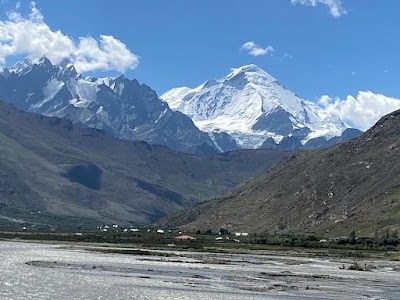
Elevation: Around 3,000 meters
Situated at an elevation of 3,000 metres, Sukhnai is one of the northernmost villages in the Warwan Valley. When the river descends from its glacial source, the Sukhnai village is the first major inhabited settlement that comes. It is home to traditional architecture where people live in wooden houses. The communities are a mix of Kashmiri- and Dardic-speaking communities.
Sukhnai is a picturesque hamlet surrounded by tall conifers and alpine grassland. Local communities take their livestock for seasonal grazing.
Inshan – Heart of Upper Warwan
The next village that falls downstream is Inshan. It’s a cultural and economic hub for upper Warwan that is a slightly larger and more developed village.
Around the village, the terraced field along with walnut and apricot trees looks pleasing to the eyes. The hamlet is a slightly larger and more developed village than Sukhnai. Village people’s livelihoods are supported by agriculture and livestock.
The village is quite popular among the trekkers and acts as the base for treks into remote glacier zones and passes like Kaintal Pass and Asti Gali.
Margi and Basmina – Middle Warwan Settlements
As the Marusudar River gains volume, it reaches the mid-valley zones near Margi and Basmina.
Margi is a small and serene hamlet with few homes and expansive fields. It lies on the bank of the Marusudar River near Margi and Basmina. The Marusudar river gains volume here with side channels and gravel banks.
Basmina: Basmina: The village is more populous with facilities like schooling and health care services. Irrigation canals in the region help in growing buckwheat, peas, and potatoes.
In the past, the areas were often prone to flooding during rapid glacial melts or cloudbursts. It highlights how a river changes its nature even in calmer sections.
Afti and Warwan (Central Region)
The river then reaches the village of Afti, near which the administrative block of Warwan (also called Warwan proper) is located. This is the most populated zone of the valley and serves as its administrative and cultural centre.
It’s the central meeting point for villagers from all parts of the valley. Several fairs and religious festivals take place along the riverbank. Agriculture in the region is more prevalent because of the broader riverbed that brings more accessible water for agriculture.
Being near administrative blocks, there are availabilities of facilities like schools, basic health centres, and village panchayats.
Nawapachi and Dool—Lower Warwan Region
Descending into the lower reaches of the Warwan Valley, the river passes through Nawapachi and Dool.
Nawapachi: Known for its fertile fields and relatively flatter topography. The river begins to pick up speed here, with rapids and deeper pools forming.
Dool: The last major village before the river merges into Chenab. It lies at the confluence zone of different tributaries, making the river significantly wider.
This region is also one of the most scenic, with dense pine forests, making it ideal for short nature treks. However, it remains underdeveloped in terms of tourism.