Image Source: G S
About Hanle
Hanle is located in the Changthang region of Ladakh. The high-altitude region sits at an elevation of close to 4300 meters (with the observatory at 4500 meters). It is situated about 260 km from Leh town and very near to the Line of Actual Control.
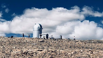
When you reach Hanle, you feel one of the most beautiful, enchanting, calm and soul-losing places in India. Hanle monastery offers out-of-the-world breadmaking views from the hilltop Hanle Monastery. A key feature is the Indian Astronomical Observatory, noted as the world’s highest observatory (or second highest optical observatory currently).
However, behind the beautiful views lies a harsh weather that is extremely harsh especially in winter and difficult to survive. Facilities like electricity, toilets, and medical aid are considered luxuries.
Acute mountain sickness
Anyone visiting Hanle requires significant preparation regarding the high altitude and the risk of acute mountain sickness (AMS).
The best time to visit is considered May to September, which offers a very pleasant season.
Permit requirement
Reaching Hanli is in itself a task. It involves driving from Leh via routes like the one through Chumathang, Mahe, Nyoma, and Loma. Although there are other routes from Pangong Tso and Tso Moriri.
Since 2022, the need for an Inner line permit for sightseeing in Ladakh has been removed. Historically, permits were needed for Hanle due to its proximity to the border. But tourists now have to pay the Ladakh ecology fee online.
Accommodation
Situated in a remote location, the accommodation options at Hanle are limited. Many homestays and guest houses have become available by 2023 in the village. Some well-known ones like Padma Homestay/Sonam Guest House can get very congested and loud due to the rush in the peak season. The observatory guest house is no longer available for tourists.
Other things to Keep in Mind
Food options are very limited and tourists have to eat at homestays.
Mobile connectivity is very limited.
No Atm facilties required visitors to carry sufficient cash from Leh or Nyoma.
If you are coming by car or personal vehicle, fill up your fuel tank, as there is no petrol pump in Hanle.
However, despite all these difficulties, Hanle offers a unique, offbeat experience for travellers willing to embrace basic facilities and undertake necessary preparations, particularly regarding altitude acclimatisation and logistics like fuel.
Trekking Routes From Hanle
Hanle is situated in the remote Changthang region of Ladakh, and travel routes from Hanle connect it to other significant, often high-altitude, destinations in the area or serve as a way to exit the region. Planning travel from Hanle involves considerations like distance, road conditions, fuel availability, and historical/current permit requirements or army checks.
The primary routes discussed from Hanle are:
Hanle to Tso Moriri
This is a common route connecting two major lake destinations in Changthang.
There are different variations mentioned:
Via Mahe bridge: This route goes through Loma, Nyoma, Mahe, and Sumdo, finally reaching Korzok (Tso Moriri). The distance is approximately 161 km.
Via Chumur: This route is shorter, about 145 km, going through Salsal La and Charchagan La before reaching Korzok. This route is described as more adventurous because of desolation. It required a 4×4 vehicle to navigate on the paths. However, visiting this sector of Chumar is hard and there are chances that the army might stop you from visiting this border region.
Via Kyun Tso / Thit Zarbo / Nidar
This route connects Hanle to Tso Moriri via Kyun Tso, Thit Zarbo, Nidar, Nyoma, and Mahe. Similar to the Chumur route, it’s considered very tough and requires a 4×4, with guaranteed desolation and lack of assistance. Kyun Tso twin lakes are near the ascent of Salsal La and can be done as a day trip from Hanle.
Normal SUVs might struggle for the Kyun Tso routes. Similar to the Chumur route, it’s considered very tough and requires a 4×4 vehicle. It connect Hanale via Kyun Tso, Thit Zarbo, Nidar, Nyoma, and Mahe.
This route is often part of an itinerary that visits Hanle after Pangong Tso and proceeds to Tso Moriri without returning to Leh.
Significant fuel needs must be considered for this stretch, as there are no petrol pumps between Hanle and Tso Moriri or between Tso Moriri and places like Karu/Leh or Tandi/Keylong if exiting towards Manali.
Hanle to Umling La Pass
The journey to Uming la pass is about 73 km from Hanle via Photila Pass or about 88 km via the Ukdungle village route.
By Photila pass
The route via Photila Pass goes through Photile Village and Chisumle Bridge. It involves two bridges/water crossings.
By Ukdungle route
The Ukdungle route is shorter in terms of time (about a 6-hour round trip) but is more of a dirt track up to Nurbula Top before improving.
Historically, civilians were not allowed to visit Umling La Pass. This required a special stamp on the permit from the DC office. However, as of the end of the 2021 season, authorities started allowing some people, and by June 2022 and September 2023, it seems there are no restrictions, with no permits or environmental slips being asked for.
Visiting Umling La Pass is a possible day trip from Hanle.
Hanle to Leh
This is the main route, taking about 275 km that connects Leh to Hanle. It includes a journey via Loma, Nyoma, Mahe, Chumathang, Upshi, and Karu. The road is paved pretty well, making it a preferred route among visitors to Hanle. It typically takes around 9-10 hours.
Fuel availability
There are no petrol pumps between Hanle and Karu/Leh (except possibly black fuel in places like Chumathang or Hanle, which is not recommended due to mixing with other elements).
Remoteness and Facilities:
Hanle is a remote village located in the southeast of Ladakh near LAC. Once you leave Hanle to any of these routes, there are no facilities like food joints, reliable phone signals (BSNL is available in Hanle but unreliable; no other network), medical aid, petrol pumps, or ATMs. So carrying sufficient cash, fuel, water, and a basic medical kit is crucial.
Altitude and Acclimatisation:
Hanle is situated at a height of 4300m and reaching it involves traversing high passes and regions. Without proper acclimatization at Leh or some other place, there is always chance of acute mountain sickness (AMS)
Vehicle Suitability
While the main route back to Leh is largely well-paved, routes like those to Tso Moriri via Chumur/Kyun Tso or towards Umling La (dirt track sections) are more challenging. Higher ground clearance vehicles are preferable, and 4×4 might be helpful on difficult sections, though not always strictly required. The condition can depend on the time of year and recent weather.
Permits and Army Presence
Historically, permits were required for Hanle and routes near the border (like Chusul, Tsaga, Loma, and Chumur).
But from 2022, domestic tourists generally only need to pay the Ladakh Ecology Fee. However, the presence of the army near the border means they can still decide to restrict access on certain routes like Chusul or Chumur, even with permits (in earlier times) or the lack thereof now.
Google Maps
FAQs
1. Where is Hanle located?
Hanle is a remote village in the Changthang region of eastern Ladakh, situated at an altitude of around 4,500 meters (14,764 feet) above sea level near the India–China border.
2. What is Hanle famous for?
Hanle is best known for the Indian Astronomical Observatory, one of the highest observatories in the world, and for its exceptionally clear night skies that make it a premier destination for stargazing and astrophotography.
3. Do I need a permit to visit Hanle?
Yes. Indian citizens generally require an Inner Line Permit (ILP) to visit Hanle and other protected areas of eastern Ladakh. Foreign nationals should check the latest travel regulations before planning their trip.
4. How far is Hanle from Leh?
Hanle is approximately 250–280 kilometers from Leh, depending on the route taken. The journey usually takes 7 to 9 hours by road.
5. What is the best time to visit Hanle?
The best time to visit Hanle is from May to September when roads are open and weather conditions are relatively favorable. Winter visits are possible but can be challenging due to extreme cold and snowfall.
6. Can tourists visit the Hanle Observatory?
Visitors can view the observatory from outside, but access to the scientific facilities is generally restricted because it is an active research center operated by astronomers.
7. Why is Hanle considered one of the best places for stargazing?
Hanle has minimal light pollution, high altitude, dry air, and clear atmospheric conditions, making it one of the finest locations in India for observing stars, planets, and the Milky Way.
8. Are accommodation facilities available in Hanle?
Yes. The village offers homestays, guesthouses, and a few small lodges where travelers can experience local Ladakhi hospitality.
9. What are the main attractions near Hanle?
Popular attractions include Hanle Monastery, the Indian Astronomical Observatory, the vast Changthang Plateau, nearby wetlands, and scenic high-altitude landscapes inhabited by unique wildlife.
10. What wildlife can be seen around Hanle?
The Hanle region is home to several rare Himalayan species, including kiangs (Tibetan wild asses), Tibetan wolves, Himalayan marmots, black-necked cranes, and various migratory birds.


