Image Source: chander dost
About Kandi Upland
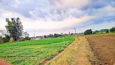
“Kandi” is a local word used for the gently rolling foothill belt that lies at the base of the Shivalik Hills. This landscape stretches across parts of Punjab, Haryana, Himachal Pradesh, and Jammu, forming a natural transition between the flat plains and the rising hills.
In Punjab, the Kandi region runs almost parallel to the Shivalik range. It’s a quieter, less-explored side of the state—where the terrain begins to ripple, forests appear in patches, and seasonal streams shape the land.
Where is it Located in Punjab?
The Kandi belt in Punjab mainly covers parts of:
- Hoshiarpur District
- Rupnagar District (Ropar)
- Parts of Gurdaspur District, Pathankot, and Shaheed Bhagat Singh Nagar
These areas lie to the northeast of Punjab’s fertile plains and gradually slope upward into the outer Himalayas.
Key Geographical Features
Terrain
The landscape here is defined by low, undulating hills, seasonal streams (locally called choes), shallow valleys, and patches of forest. It’s not quite plains, not quite hills—something in between.
Soil
The soil is sandy and gravelly, which makes it vulnerable to erosion, especially during heavy rains.
Climate
Compared to the plains, the Kandi region feels slightly cooler. Monsoons bring heavier rainfall due to the proximity of the hills.
Hydrology & Dams
One of the most distinctive features of the Kandi belt is its network of seasonal rivulets flowing down from the Shivaliks. These streams can swell rapidly during the monsoon and remain dry for much of the year.
To manage water flow and reduce flooding, several small dams have been built in the region, including:
- Damsal Dam.
- Maili Dam.
- Chohal Dam.
- Jainti Dam.
These dams play a crucial role—storing rainwater for irrigation, supplying drinking water, controlling floods, and helping recharge groundwater in this fragile landscape.
Why the Kandi Region Matters
A Natural Buffer
The Kandi belt acts as a protective layer between the fragile Shivalik hills and the fertile plains, helping to control soil erosion and runoff.
Water Lifeline
For local farmers, the reservoirs and dams here are vital, especially during dry months.
Distinct Rural Culture
Life in Kandi villages blends the cultures of both plains and hills. You’ll find traditional farming practices, local folklore, and a slower, more grounded way of living.
Biodiversity Hotspot
The region is home to forest patches and wildlife areas like Takhni-Rehmapur Wildlife Sanctuary and nearby wetland ecosystems such as Keshopur Wetland.
Travel Highlights
For travelers, the Kandi upland offers a refreshing change from Punjab’s usual landscape:
- Peaceful nature spots like Damsal Dam and Chohal Dam.
- Scenic drives through rolling countryside with Shivalik views.
- Birdwatching, picnics, and easy nature walks.
- Hidden historical sites such as Dholbaha Archaeological Site, which reveal layers of ancient history.
It’s not a typical tourist destination—and that’s exactly its charm.
Best Time to Visit
- October to March: Comfortable weather, clear skies—ideal for exploring.
- July to September (Monsoon): The landscape turns lush and green, though streams can swell quickly—great for photography but requires caution.
How to Explore
- Base Cities: Hoshiarpur or Rupnagar.
- Getting Around: Private car, local taxis, or guided rural tours.
- Stay Options: Simple guesthouses, rustic farm stays, or day trips from nearby towns.
Why Travelers Should Care
The Kandi upland reveals a different side of Punjab—far from busy cities and endless farmlands. Here, the land gently rises toward the hills, forests whisper in the background, and seasonal streams quietly shape the terrain. It’s a place where nature, culture, and simplicity come together in a way that feels authentic and unhurried.
FAQs
1. What does “Kandi” mean?
“Kandi” refers to the undulating foothill zone at the base of the Shivalik Hills, marking the transition between plains and hills.
2. Is the Kandi region good for tourism?
Yes, especially for those who enjoy offbeat destinations, nature, and rural experiences. It’s more about quiet exploration than mainstream sightseeing.
3. Which is the best place to start exploring Kandi in Punjab?
Hoshiarpur and Rupnagar (Ropar) are the most convenient base towns.
4. Are there good accommodation options?
Options are basic within the region, but nearby towns offer comfortable hotels. Farm stays are also becoming popular.
5. What activities can you do here?
You can enjoy scenic drives, birdwatching, picnics, short treks, and visits to dams and wildlife areas.
6. Is it safe to visit during monsoon?
Yes, but with caution. Seasonal streams can flood quickly, so it’s important to keep an eye on weather conditions.
7. How is Kandi different from the rest of Punjab?
Unlike the flat agricultural plains, Kandi has a more rugged, hilly terrain with forests, streams, and a distinct cultural blend of plains and hill traditions.


