Image Source: Amit Tiwary
About Harunta Bugyal
In the Uttarkashi district of Uttarakhand, there are dozens of beautiful Bugyals that are waiting to be explored. One of such Bugyals is Harunta Bugyal, which lies at an altitude of 2900 meters in the Ganga-Yamuna valley. Bugyal is also the source of the Indravati River that joins the Bhagrathi at Uttarkashi.
Every year, villagers from Badgaddi Paati worship the source of Indravati, signifying its religious importance.
Puranas
Harunta Bugyal is mentioned in the Skand Purana of Kedarkhand. The surrounding area around Haruna Bugyals is written or known by the name Indrakeel Parvat.
Trek to Harunta Bugyal
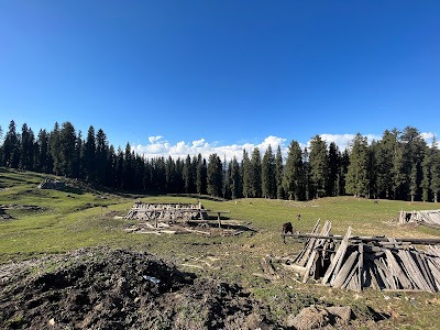
The trek to Haurnta Bugyal starts from a village called Chaurangi that lies on the Kedarnath road and is at a distance of 52 km from Uttarkashi. During the trek, the dense forest of Banj, Buransh, takes you into a different world where calm sounds of wind and birds flow . During the trek , the first major attraction that falls is Chhota Bugyal Falls at a distance of 1 km . It’s also called Khal Bugyal. It takes you around 3 to 4 hours to cover a distance of 7 km to reach Harunta Bugyal.
Once you reach the top, the old traditional Chhanis, also called Goth, are fond. It’s made of mudstone and wood, where generally animals come to life during the summer and rainy seasons. These cow sheds have been built in forests since ancient times.