Image Source: http://www.cepf.net/wikimedia
What Is the Nilgiri–Eastern Ghats Corridor
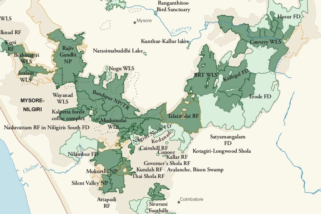
The Nilgiri–Eastern Ghats Corridor is one of India’s most important wildlife movement landscapes. It is a natural ecological link that connects the Western Ghats forests such as Nilgiri, Mudumalai, Bandipur, and Wayanad with the Eastern Ghats forests, mainly through Sathyamangalam Tiger Reserve and nearby forest tracts.
In simple terms, this corridor acts like a biological highway. It is not a man-made road but a continuous stretch of forests, grasslands, and river valleys that allow wildlife to move freely between two major mountain systems of peninsular India.
Where the Corridor Is Located ?
The corridor lies mainly across northern Tamil Nadu and southern Karnataka, passing through a strategically important landscape made up of:
The Sigur Plateau, a gently sloping forested tableland
The Moyar Valley, shaped by the Moyar River
Forests of Mudumalai Tiger Reserve
The Sathyamangalam Tiger Reserve, which forms the key bridge toward the Eastern Ghats
Geographically, the corridor is naturally defined:
Nilgiri Hills rise on one side.
Moyar River and valley open pathways on the other.
This terrain creates a natural passage through otherwise rugged hills, making it easier for large animals to move across regions.
What the Corridor Connects
The Nilgiri–Eastern Ghats Corridor links multiple protected areas into one large connected wildlife landscape.
On the Western Ghats side, it connects:
Mudumalai National Park
Bandipur National Park
Nagarhole National Park
Wayanad Wildlife Sanctuary
On the Eastern Ghats side, it connects:
Sathyamangalam Tiger Reserve
Forests extending toward the Cauvery Wildlife Sanctuary and interior Eastern Ghats
Because of this connectivity, animals can move across hundreds of kilometers, instead of being trapped inside isolated forest patches.
Wildlife That Uses the Corridor
This corridor is especially important for wide-ranging and migratory species.
Asian elephants use it as a seasonal migration route to access food, water, and breeding areas.
Tigers move through these forests to establish new territories and maintain healthy populations.
Other animals such as leopards, gaur, sambar deer, chital, wild dogs, and smaller carnivores also benefit from this open connectivity.
The corridor supports genetic exchange, allowing animals from different reserves to interbreed. This reduces inbreeding and strengthens long-term survival of wildlife populations.
Key Characteristics of the Corridor
Mixed Forest and Open Habitats
The corridor is not one continuous dense forest. It includes:
Moist deciduous forests
Dry deciduous forests
Scrublands
Grasslands
Riverine vegetation
This diversity allows animals to rest, feed, drink water, and move safely along their journey.
Lowland Plateaus and River Valleys
Landforms like the Sigur Plateau and Moyar Valley create flatter, gentler routes compared to steep hill slopes. Large animals, especially elephants, prefer these landscapes for long-distance movement.
Seasonal Wildlife Movement
Animal movement through the corridor changes with seasons:
During dry months, animals move toward greener areas and water sources
During monsoons, they spread into higher and denser forest zones
This makes the corridor a dynamic and living landscape, not a fixed route.
Genetic Connectivity
The corridor plays a crucial role in genetic flow between wildlife populations. Healthy genetic diversity is essential for disease resistance, reproductive success, and long-term ecosystem stability.
Human Influence and Conservation Importance
The corridor passes close to villages, farmlands, highways, and tourism zones, which makes it fragile.
To protect it
Certain corridor lands receive legal and ecological protection
Courts have recognized the right of passage for elephants, stopping construction projects that block movement routes
Conservation groups use satellite mapping, field surveys, and community engagement to reduce human–wildlife conflict
Protecting the corridor means protecting both wildlife and human livelihoods.


