Image Source: Udhav Panwar
About Mana Pass
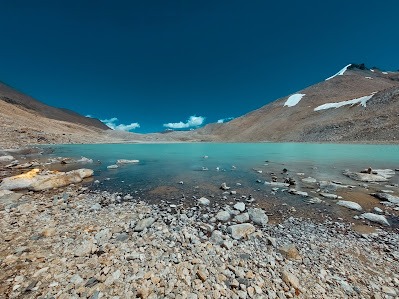
Mana Pass, also known as Mana La, Chirbitya-La, Chongnyi La, or Dungri La, is one of the highest mountain passes in the Himalayas and an important frontier route on the India–China border. Located in the Chamoli district of Uttarakhand, the pass rises to an elevation of around 5,610 meters (18,406 feet) above sea level. Because of its extreme altitude and difficult terrain, Mana Pass is considered one of the world’s highest motorable routes.
The pass lies deep within the spectacular Himalayan landscape north of Mana Village, often referred to as the last Indian village before the Tibetan frontier. Surrounded by snow-clad peaks, glaciers, frozen streams, and barren high-altitude valleys, the region has a raw and dramatic beauty that feels untouched by time.
Mana Pass is not just geographically significant; it also holds historical, cultural, and strategic importance. For centuries, it served as an ancient trade and pilgrimage route connecting India with Tibet. Today, although civilian movement is heavily restricted, the pass remains crucial from a military and geopolitical perspective.
Historical Importance of Mana Pass
Ancient Trade Route Between India and Tibet
Long before modern roads and political boundaries existed, Mana Pass functioned as a vital trade corridor through the Himalayas. Traders from the Garhwal region traveled across this rugged route into Tibet carrying goods such as grains, jaggery, spices, textiles, and metal items. In return, Tibetan merchants brought wool, salt, borax, and livestock products into the Indian Himalayas.
This exchange was not limited to commerce alone. The route also encouraged cultural interaction between Himalayan communities. Languages, traditions, religious practices, and lifestyles were influenced by centuries of contact between Indian and Tibetan societies. Small settlements along the route became resting points for traders, monks, pilgrims, and nomadic groups moving through the mountains.
Despite the harsh weather and dangerous terrain, Mana Pass remained active for generations because it provided one of the most direct links between the central Himalayas and Tibet.
European Explorers and Early Documentation
Mana Pass also gained historical recognition during the early European exploration of the Himalayas. In 1624, Portuguese Jesuit explorers António de Andrade and Manuel Marques crossed the pass while traveling toward Tibet. Their expedition became one of the earliest recorded European journeys through this remote Himalayan region.
The accounts written by these explorers introduced European scholars and geographers to previously unknown parts of the western Himalayas and Tibet. Their journey highlighted the existence of long-standing Himalayan trade routes and demonstrated how connected these remote mountain regions had been for centuries.
Closure of Traditional Trade Routes
The role of Mana Pass changed significantly during the mid-20th century. After political tensions emerged between India and China, especially following the 1962 Sino-Indian conflict, cross-border movement through the pass was gradually restricted.
Although agreements signed during the 1950s allowed limited pilgrimage and traditional travel, regular trade activities eventually stopped. Since then, Mana Pass has largely remained under military supervision because of its proximity to the Line of Actual Control (LAC).
Today, the route no longer functions as an active commercial trade corridor, but its historical legacy still survives in the stories, traditions, and memories of Himalayan communities.
Meaning and Origin of the Name “Mana”
The name “Mana” is believed to have originated from “Manibhadra Ashram,” an ancient spiritual site associated with the region. Over time, the settlement nearby became known as Mana village, and the mountain pass north of it naturally came to be called Mana Pass.
The area is deeply connected with Hindu mythology and local Himalayan traditions. According to regional beliefs, the region is associated with Devi Manaswini, who is regarded in some traditions as a daughter of Lord Shiva. Because of these mythological connections, the landscape around Mana is considered spiritually sacred by many pilgrims and local residents.
Even today, travelers visiting Mana village often feel a strong sense of spiritual atmosphere because the region lies close to famous pilgrimage sites such as Badrinath Temple.
Geography and Natural Landscape
Extreme High-Altitude Environment
Mana Pass is located roughly 47 kilometers north of Mana village and around 52 kilometers from Badrinath. At an elevation exceeding 5,600 meters, the environment here is extremely harsh. Oxygen levels are low, temperatures remain freezing for much of the year, and strong winds frequently sweep across the barren mountain slopes.
During winter, heavy snowfall completely blocks the route. Snow accumulation usually begins around November and can continue until April or even later depending on weather conditions. For several months, the region becomes inaccessible due to thick snow and dangerous conditions.
The terrain around the pass consists of rocky mountains, glacial valleys, ice fields, and sparse alpine vegetation. Because of the altitude, only specially adapted plants and wildlife survive in this cold desert-like ecosystem.
Part of the Nanda Devi Biosphere Region
Mana Pass falls within the broader ecological zone associated with the Nanda Devi Biosphere Reserve, one of India’s most important protected Himalayan landscapes. The region supports fragile alpine ecosystems, high-altitude medicinal plants, and rare mountain wildlife.
The surrounding Himalayas are home to species such as Himalayan blue sheep, snow leopards, Himalayan marmots, and various migratory birds. Due to the ecological sensitivity of the area, human activity is carefully monitored.
Rivers and Watershed Significance
The region near Mana Pass is hydrologically important because it contributes to the headwaters of major Himalayan rivers. The sacred Saraswati River originates near this area before eventually joining the Alaknanda River system, which later forms part of the Ganges basin.
The pass also acts as a watershed divide. Rivers flowing southward contribute to Indian river systems, while northern drainage flows toward the Tibetan plateau and eventually into river systems connected with the Indus and Sutlej basins.
Because of this geographical role, Mana Pass has long been important not only for travel but also for understanding Himalayan water systems.
Road Connectivity and Strategic Importance
Construction of the High-Altitude Road
Building a motorable road to Mana Pass was an enormous engineering challenge. Between 2005 and 2010, the Border Roads Organisation (BRO) constructed a strategic road connecting the lower Himalayan valleys with the high pass region.
The steep slopes, freezing temperatures, landslide-prone terrain, and short working season made construction extremely difficult. In some stretches, engineers reportedly had to build the road from the upper sections downward because of the unusual terrain conditions.
Today, this road is primarily used for military transportation, border patrol, and logistical support operations rather than regular tourism.
Military and Geopolitical Importance
Mana Pass holds major strategic value because it lies along the sensitive India–China frontier. The region is monitored by the Indian Army and the Indo-Tibetan Border Police (ITBP), both of which maintain a strong presence in the area.
The road forms part of India’s larger border infrastructure development program aimed at improving rapid troop movement and supply transport in high-altitude regions. Better road connectivity allows faster deployment of defense personnel and equipment in case of emergencies along the Himalayan frontier.
Because of the region’s strategic sensitivity, civilian access beyond certain checkpoints requires special permission, usually in the form of an Inner Line Permit.
Future Infrastructure Development
The road toward Mana Pass is expected to undergo further widening and modernization in the coming years. Authorities plan to improve the route to support heavier military vehicles and faster movement of supplies through the Himalayas.
Such infrastructure projects are considered crucial because high-altitude border regions face severe logistical challenges during winter and adverse weather conditions.
Why Mana Pass Matters Today
A Symbol of Himalayan Heritage
Even though trade routes through the pass are no longer active, Mana Pass continues to symbolize the centuries-old relationship between India and Tibet. It represents a time when the Himalayas connected cultures instead of dividing them.
The route reflects the resilience of ancient Himalayan traders and travelers who crossed dangerous mountain terrain long before modern roads existed.
Strategic Border Significance
Today, Mana Pass is mainly important from a national security perspective. Its location near the India–China border makes it one of the strategically sensitive sectors of the western Himalayas.
The region allows surveillance, defense preparedness, and logistical access in difficult mountain terrain where infrastructure is otherwise limited.
A Rare and Remote Himalayan Frontier
For most travelers, Mana Pass remains an inaccessible dream because of security restrictions and harsh environmental conditions. However, its mystery, history, and dramatic landscape continue to fascinate adventure enthusiasts, geographers, historians, and spiritual travelers alike.
The pass stands as one of the most remote and awe-inspiring gateways of the Indian Himalayas.
FAQs
Where is Mana Pass located?
Mana Pass is located in the Chamoli district of Uttarakhand near the India–China border in the Great Himalayas.
How high is Mana Pass?
The pass stands at an elevation of approximately 5,610 meters (18,406 feet) above sea level.
Is Mana Pass open for tourists?
Civilian access to Mana Pass is highly restricted because of military and border security regulations. Special permits are required to travel beyond certain areas.
Which village is closest to Mana Pass?
Mana Village is the nearest settlement and is popularly known as the last Indian village near the Tibetan border
Why is Mana Pass historically important?
Mana Pass served as an ancient trade route connecting India and Tibet. Traders used the route for centuries to exchange goods like salt, wool, grains, and textiles.
Which river originates near Mana Pass?
The sacred Saraswati River originates near the Mana Pass region.
Why is Mana Pass strategically important?
The pass is strategically important because it lies near the India–China border and supports military movement, surveillance, and border defense operations.
When is Mana Pass inaccessible due to snow?
The region usually remains snowbound from November to April, though weather conditions can vary from year to year.
 , Mana Pass - Chamoli - Uttarkhand")


