Image Source: gmada.gov.in
Introduction
Aerocity Mohali is one of the most important planned urban developments in Punjab and the wider Chandigarh Tricity region. Located along the fast-growing Airport Road near Chandigarh International Airport, Aerocity represents Mohali’s outward expansion toward modern infrastructure, global connectivity, and organized township planning. Developed by the Greater Mohali Area Development Authority (GMADA), it is designed as a self-contained urban zone with residential, commercial, and community spaces integrated into a single layout.
Unlike traditional Mohali sectors that grew gradually over decades, Aerocity was conceived as a future-ready corridor, directly linked to air transport, highways, and upcoming institutional and IT zones. This makes it not just another residential area, but a strategic urban extension of the Tricity.
Historical Background and Concept
Before Aerocity existed, this entire belt was largely rural land between Mohali and the airport zone. With the construction of Chandigarh International Airport and the widening of Airport Road (PR-7), GMADA identified this stretch as a high-potential growth axis.
Originally, parts of Aerocity were recorded under sector names such as Sector 66-A East and Sector 82-A East, but over time the whole development became popularly known as Aerocity Mohali. The idea was to avoid unplanned sprawl and instead create a structured township with plotted housing, wide roads, green spaces, and defined commercial pockets.
Later, this vision expanded further into the massive Aerotropolis Mohali project, which surrounds and builds upon Aerocity, turning the airport region into a long-term urban hub rather than just a transport terminal.
Location and Connectivity
Aerocity’s greatest strength is its location.
It lies directly along the 200-foot wide Airport Road, placing it only about 5–10 minutes from Chandigarh International Airport. This corridor connects it seamlessly to:
- Chandigarh city
- Zirakpur
- Kharar
- Patiala Highway (NH-64 / NH-152)
Because of this, Aerocity functions as a bridge between Mohali and the airport, and also as a gateway for people entering the Tricity by air.
Future transport plans, including proposed metro connectivity for the airport corridor, are expected to make Aerocity even more accessible and further increase its urban importance.
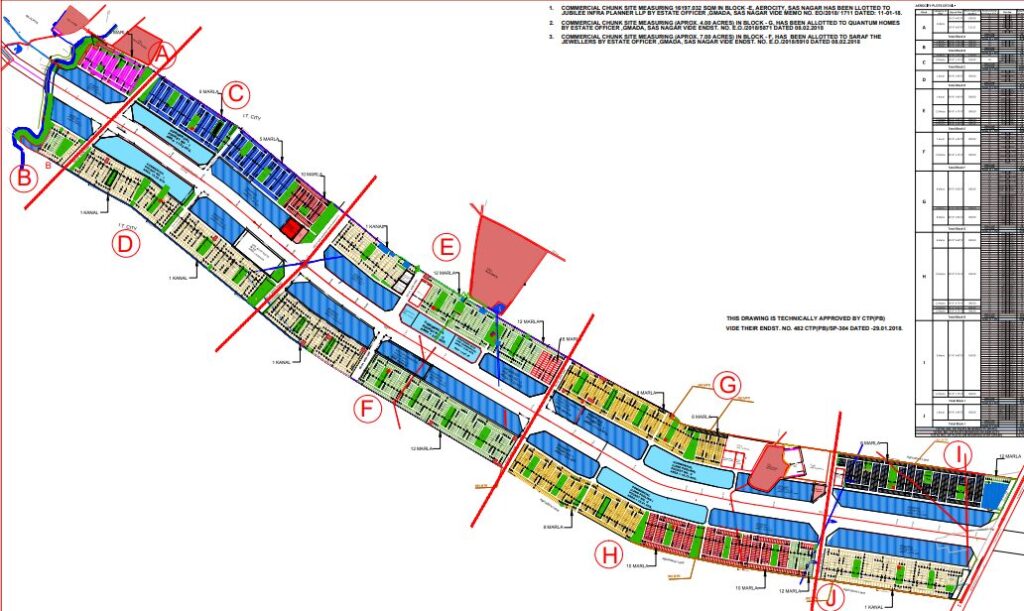
Urban Layout and Block Structure
Unlike classic Mohali sectors, Aerocity is organized into Blocks A to J rather than numbered sectors. These blocks are arranged along both sides of Airport Road, forming a long linear township.
Each block contains plotted residential pockets with different plot sizes:
- Smaller plots for compact urban homes
- Medium plots for standard family houses
- Larger plots for high-end independent residences
Together, Aerocity contains thousands of residential plots, laid out with:
- Wide internal roads (40 ft, 60 ft and above)
- Planned parks and green belts
- Utility corridors for water, power, and drainage
Commercial activity is mainly concentrated along the main road in the form of:
- Shop-cum-office (SCO) units
- Showrooms
- Mixed-use commercial complexes
This ensures that daily needs and workplaces are integrated within walking or short-drive distance, instead of being pushed far away.
Infrastructure and Planning Vision
Aerocity was designed as a modern township, not just a plotted colony. The planning vision includes:
- Underground services for electricity and water
- Dedicated green spaces
- Organized road hierarchy
- Separate residential and commercial zones
The intention was to avoid the chaotic growth seen in many Indian suburbs by giving Aerocity a clear physical structure from the beginning.
However, as with most large new townships, development has faced challenges. Issues such as underground power cable failures and temporary service disruptions have occurred during early years of occupation. These reflect the typical transition phase of a newly urbanizing zone rather than long-term decline.
Community and Lifestyle
Aerocity is no longer just land and plots — it is gradually becoming a lived-in neighbourhood. Families, professionals, and NRIs have begun building homes, and social life is slowly taking shape.
Schools, clinics, grocery stores, and small markets are emerging along with cafes and service outlets. Parks and open areas are increasingly being used for:
- Morning walks
- Sports activities
- Children’s play
- Community gatherings
This gives Aerocity the character of a young urban suburb — not fully mature yet, but clearly moving toward a stable residential identity.
Economic and Real Estate Significance
From an economic and real estate perspective, Aerocity sits at the intersection of:
- Airport-based development
- IT and institutional expansion (near IT City Mohali)
- Tricity population growth
This makes it attractive to:
- Long-term homebuyers
- Rental investors
- Commercial property buyers
Demand is driven by:
- Proximity to jobs
- Better road connectivity
- Newer infrastructure compared to old Mohali sectors
The nearby Aerotropolis Mohali project further strengthens this corridor’s future by planning hotels, offices, convention spaces, and urban amenities linked to the airport economy.
Administrative and Civic Challenges
Aerocity has also seen debates over:
- Municipal limits
- Service responsibility
- Governance structure
Because it lies at the edge of Mohali’s older urban area, questions arise about whether it should fall fully under the municipal corporation or remain under GMADA-type control. These issues influence:
- Road maintenance
- Lighting
- Waste management
- Taxation
Such transitions are common in newly urbanizing regions and usually stabilize once population density increases.
Future Outlook
In the long term, Aerocity is positioned to become:
- A major residential suburb of Mohali
- A commercial strip along Airport Road
- A key part of the airport-centric urban zone
As Aerotropolis develops, metro connectivity improves, and surrounding sectors fill up, Aerocity will likely shift from being a “new area” to being a core urban belt of the Tricity.
Its identity will evolve from:
“plots near the airport”
to “a structured urban district connected to global travel and regional employment.”
Conclusion
Aerocity Mohali represents a new model of urban expansion in Punjab — one that grows along infrastructure corridors rather than random sprawl. Rooted in the airport economy and guided by planned development, it combines residential living, commercial opportunity, and long-term strategic value.
From its origins as rural land to its current role as a fast-growing township, Aerocity reflects how modern Indian cities are reshaping themselves around transport, connectivity, and organized planning. As future projects like Aerotropolis and metro lines take shape, Aerocity is likely to become one of the defining urban zones of Mohali’s next phase of growth.


