Image Source: Biakthang Tunglut
Geographical Setting and River Gateway
Gelling village is a remote frontier settlement located in the Upper Siang district of Arunachal Pradesh, close to the Indo-China border along the McMahon Line. It occupies a critical position in the trans-Himalayan region where the Tsangpo River of Tibet enters India and becomes the Siang River, later known as the Brahmaputra. This river transition zone gives Gelling a unique physical geography marked by deep gorges, steep mountain slopes, and narrow valley floors. The surrounding terrain forms part of the eastern Himalayan corridor, characterized by landslide-prone slopes, alpine vegetation, and high-altitude climate conditions. Its location near the international boundary also places it within a sensitive border landscape shaped by both natural and political forces.
Strategic and Geopolitical Importance
From a strategic perspective, Gelling functions as one of India’s northernmost accessible settlements before the Line of Actual Control. The village lies along a historically significant route connecting the Indian subcontinent with the Tibetan plateau through mountain passes such as Kepangla. In contemporary terms, Gelling has gained relevance within border infrastructure planning, military logistics, and frontier road networks, including its proximity to the proposed Arunachal Frontier Highway. The region’s geopolitical importance is reinforced by its role in monitoring river systems, mountain passes, and cross-border movement, making it part of India’s broader Himalayan security architecture.
Ethnic Composition and Cultural Identity
The population of Gelling is small and socially cohesive, largely belonging to the Memba tribal community, whose cultural roots are closely linked with Tibetan civilization. The social fabric reflects a blend of indigenous tribal traditions and Mahayana Buddhist practices, particularly of the Nyingma school. Cultural life is shaped by monastic rituals, prayer flags, and seasonal ceremonies that integrate spiritual beliefs with the surrounding natural environment. Traditional houses made from wood and bamboo, along with subsistence farming and animal rearing, illustrate a livelihood system adapted to high-altitude ecological constraints. Oral traditions, clan ties, and village councils continue to regulate social order in this remote Himalayan settlement.
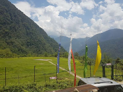
Religious Landscape and Sacred Geography
Gelling’s landscape is not only physical but also deeply symbolic, forming part of a sacred Himalayan geography. Rituals such as the Riwo Sangcho (sacred smoke offering) performed at nearby mountain passes highlight the spiritual connection between land, sky, and community. Festivals such as Druba and Losar involve masked dances, monastic chants, and offerings intended to protect the border region and ensure harmony between humans and nature. The surrounding mountains are often perceived as guardian deities, transforming the village into a living religious map where geography itself becomes an object of worship. This fusion of terrain and belief gives Gelling a strong identity as a cultural frontier zone.
Ecology and Natural Environment
Ecologically, Gelling lies within a transitional belt between the Tibetan plateau and the eastern Himalayan forests. The region supports alpine meadows, high-altitude shrubs, and riverine ecosystems shaped by glacial meltwater. Nearby waterfalls, mountain lakes, and forest trails form part of an emerging eco-tourism potential. Wildlife habitats remain relatively undisturbed due to limited human population, contributing to biodiversity conservation. However, climatic extremes, soil erosion, and limited arable land restrict agricultural productivity, making ecological balance essential for survival in this fragile mountain system.
Connectivity and Development Challenges
Despite its importance, Gelling remains geographically isolated, accessible mainly through Tuting town by difficult mountain roads and trekking routes. Development efforts focus on road expansion, communication networks, and basic services such as education and healthcare. Border road projects aim to integrate Gelling into the national transport grid while supporting defense mobility. At the same time, modernization introduces tensions between traditional lifestyles and infrastructural transformation. Limited market access and seasonal road blockages continue to shape daily life, reinforcing the village’s status as a peripheral yet strategically vital settlement.
Tourism and Cultural Frontier Potential
From a tourism and research perspective, Gelling represents a rare cultural frontier where geography, religion, and geopolitics intersect. Its appeal lies not in conventional sightseeing but in its role as a river gateway, border village, and cultural threshold between India and Tibet. Trekking routes, Buddhist festivals, and river landscapes offer experiential travel opportunities linked to Himalayan history and frontier studies. With careful planning, the village could serve as a model for sustainable tourism based on heritage conservation, ecological awareness, and cross-cultural interpretation.


