About Thamsar Pass
The Chamba to Kangra route via Bara Bhangal and Thamsar Pass is considered one of the toughest and most remote Himalayan crossings. Thamsar Pass, at an altitude of around 4665 meters, takes around about seven days within the rugged embrace of the Dhauladhar range.
The best time to consider this article is from June to October, when the snowmelt and weather conditions are manageable.
Chamba – Holi – Nayagram
The adventure begins at Holi , a small bus terminus that serves as the last point of motorable access. Here, basic facilities like rest houses and provision stores help trekkers make their final preparations. The initial stretch towards Nayagram is deceptively beautiful but fraught with narrow cliffside trails, sheer rock faces, and deep ravines—sections where at times, only a precarious half-footing is available. It’s no surprise that many trekkers, facing this reality, choose to turn back here.
Nayagram to Dhardi and Khanar (Approx. 6–8 Hours)
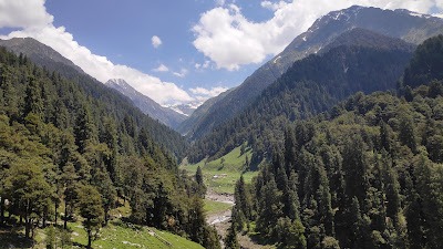
Covering nearly 26 kilometers, this stage demands stamina as the path dips down to meet the Ravi River, only to climb sharply up to Bajol village. A steady climb brings you to Dhardi, a quaint village perched on a ridge with a good camping site near a water source. Continuing further, the trail winds to Khanar, the final settlement on the Chamba side. This belt is home to small pastoral communities like Bajol and Graunda, whose residents often migrate to the warmer Kangra valley during the harsh winters.
Khanar to Bara Bhangal (Approx. 6–8 Hours)
One of the trek’s most challenging stretches, this 18-kilometer trail traverses knife-edge ridges, treacherous gorges, and near-vertical rock slopes where any misstep can be fatal. Eventually, the path drops down to Bara Bhangal , an ancient, isolated village tucked away at 2511 meters at the meeting point of the Ravi River and Kalihini Nallah.
Bara Bhangal is one of Himachal’s remotest habitations, accessible only by foot. The community here lives in primitive conditions—without electricity, residents rely on dried pine roots ( jagni ) for light and fuel. A basic rest house offers weary trekkers shelter.
Bara Bhangal to Marh (Approx. 4 Hours)
The next stage is a comparative respite—an easier, well-worn shepherd trail crossing rustic wooden bridges over the Ravi and Kalihini streams. After a gentle climb, you’ll reach Marh, a seasonal stone shelter used by Gaddis as a grazing camp. It’s a peaceful spot for camping, but trekkers must carry all essentials since no supplies are available here.
Marh to Panihardu via Thamsar Pass (Approx. 7–8 Hours)
An early dawn departure—ideally by 4:30 AM—is crucial for this day’s climb. The ascent to Thamsar Pass is steady but can be strenuous in stretches, especially if late-season snow lingers. The pass, one of the more spectacular in the Dhauladhar, unveils sweeping snowfields and, at the top, reveals a mesmerizing glacial lake flanked by two smaller tarns. However, the descent on the Kangra side is steep, with slippery rock slabs demanding caution.
The trail then leads to Bharpal (or Bherpal Got), a seasonal shepherd encampment, before easing down to Panihardu, a traditional camping meadow where basic seasonal food and temporary shelters can be found.
Panihardu to Palachak (Approx. 2–3 Hours)
A well-marked trail leads through lush alpine meadows to Palachak , a popular resting point with a seasonal dhaba (small tea shop) and good camping spots. It’s a perfect place to relax, recover, and soak in views of the surrounding high ridges.
Palachak to Billing and Baijnath
From Palachak, a scenic mule track takes about two hours to reach Rajgundha , a charming village with a camping site and tiny provisions shops. Another two hours brings trekkers to Billing (2600 m)—an internationally acclaimed paragliding launch site.
During the post-monsoon season, Billing transforms into a bustling hub for adventure sports lovers, with camping grounds and basic rest house facilities. From here, a 14-kilometer motorable road descends to Bir , a Tibetan settlement known for its monasteries and eco-cafes. Buses from Bir connect you to Baijnath , which is about 56 kilometers from Dharamsala and famous for its ancient Shiva temple.
Alternative Exit: Palachak to Baragaon and Barot
For those seeking a different exit, another route branches down to Baragaon , a traditional village ringed by potato and kidney bean terraces. This area falls under Chhota Bhangal in Kangra district and is linked by road to Barot , a quaint hamlet straddling the Mandi district border. Barot is a hidden gem with a trout fish farm, a hydroelectric reservoir, a forest rest house, and a small bazaar. From Barot, buses run to Mandi and Jogindernagar, connecting trekkers back to the main Himachali road network.
Why This Trek is Special?
This trail is not merely about crossing a pass; it’s an odyssey through hidden shepherd trails, centuries-old Gaddi hamlets, and remote valleys that modern roads still haven’t touched. The stark beauty of the Dhauladhar’s snow ridges, the primal solitude of Bara Bhangal, and the final thrill of emerging at Billing’s famed paragliding slopes make this trek a true Himalayan classic—demanding, dangerous, and deeply rewarding for those who dare.


