Image Source: Rohit Gosain
About Kamet Massif
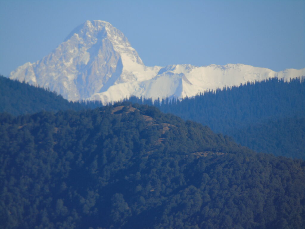
When people look at the Kamet Massif on a map, it often appears as a single, imposing block of ice and rock rising from the Garhwal Himalaya. In reality, Kamet is not one uniform mountain unit. It is a living, interconnected mountain system shaped by glaciers, valleys, rivers, climate, and centuries of human movement. To truly understand Kamet, especially from a geographical and travel perspective, it helps to break the massif into its natural sub-systems: the Abi Gamin system, the Mana system, and the Niti system.
Each of these sub-systems functions differently. They collect snow in different ways, release water at different times, support different forms of vegetation, and interact with people in distinct ways. Together, they explain why Kamet behaves the way it does as a mountain massif.
Why Kamet Needs to Be Studied as Sub-Systems ?
Large Himalayan massifs do not behave like isolated peaks. They work more like natural machines, where snow accumulation, glacial flow, river discharge, and climate feedback are constantly interacting. By dividing Kamet into sub-systems, we can understand where ice is stored, where water is released, where life survives, and where human routes have developed.
For geographers, this approach reveals structure and process. For travelers, it explains terrain difficulty, weather behavior, and accessibility. What looks like a single massif from a distance is, in fact, a layered landscape with very different personalities.
The Abi Gamin Sub-System: Kamet’s High-Altitude Glacial Core
The Abi Gamin sub-system forms the northern and northeastern heart of the Kamet Massif. This area faces the Tibetan Plateau and lies at extremely high elevations, where temperatures remain low for most of the year. Because of this orientation and altitude, Abi Gamin functions as the primary ice storage zone of the massif.
The terrain here is dominated by broad glacial basins rather than sharp valleys. Snow accumulates slowly but persistently, building thick ice fields that feed the Abi Gamin Glacier. Unlike steeper glaciers further south, ice movement here is relatively slow, and melting is delayed well into the summer. This makes the Abi Gamin system critical for long-term water regulation rather than immediate river flow.
From a climatic perspective, this sub-system experiences dry, cold conditions with strong winds and minimal cloud cover. The Indian monsoon rarely penetrates this region effectively, which is why vegetation is almost absent. Only hardy mosses and lichens manage to survive in sheltered micro-environments.
Human presence in the Abi Gamin system is virtually non-existent. There are no settlements, no grazing grounds, and no pilgrimage routes. This is a zone reserved for mountaineers, glaciologists, and serious high-altitude researchers. For travelers, it represents the raw, untouched face of the Himalaya, where geography dominates completely.
The Mana Sub-System: The Hydrological Powerhouse of Kamet
In sharp contrast, the Mana sub-system lies on the southern side of the Kamet Massif and directly faces the monsoon winds. This orientation dramatically changes everything. Snowfall is heavier, cloud cover is frequent, and glaciers melt faster. As a result, this sub-system plays the most important role in feeding rivers.
The Mana Glacier, steep and debris-covered, descends rapidly into a narrow, deeply incised valley. Meltwater from this glacier forms the upper reaches of the Alaknanda River, one of the principal headstreams of the Ganga. During late spring and summer, the Mana system releases large volumes of water, making it the hydrological engine of the massif.
The valley itself is steep, confined, and geologically active. Landslides, avalanches, and sudden water surges are part of the natural rhythm here. Vegetation appears at lower elevations, with alpine grasses, dwarf shrubs, and scattered birch and juniper forests supporting limited grazing.
What makes the Mana sub-system unique is its strong human connection. The village of Mana, near Badrinath, sits at the edge of this rugged landscape and has served as a cultural and logistical gateway for centuries. Ancient trade routes, pilgrimage paths, and modern trekking trails all pass through this system. For travelers, Mana is where high Himalayan geography meets living culture.
The Niti Sub-System: A Transitional Landscape of Balance
The Niti sub-system occupies the western side of the Kamet Massif and acts as a transition zone between the moist southern slopes and the cold northern interiors. The valleys here are wider, with classic U-shaped glacial profiles and thick sediment deposits that tell the story of past ice ages.
Glaciers in the Niti system are smaller and more fragmented, releasing meltwater at a steadier and more predictable rate. This water feeds the Niti River, which eventually joins the Dhauli Ganga. Unlike the dramatic surges seen in the Mana system, river flow here is more balanced and stable.
Climatically, Niti experiences colder conditions than Mana but less extreme dryness than Abi Gamin. This middle-ground climate allows for a richer alpine ecosystem. Meadows support seasonal grazing, and wildflowers appear during the short summer months, adding ecological diversity absent in higher zones.
Human presence in the Niti system is seasonal. Villages such as Niti were historically part of Indo-Tibetan trade networks, with people moving in and out depending on weather and political conditions. Today, this region offers some of the most educational trekking routes for those interested in glacial landforms, river systems, and human adaptation to high-altitude environments.
How These Sub-Systems Work Together
The Kamet Massif functions as a complete geographical unit only because these three sub-systems complement each other. The Abi Gamin system stores ice over long periods. The Mana system releases water quickly and powerfully into major river networks. The Niti system balances climate, ecology, and human movement.
This internal division explains why Kamet is both hydrologically vital and environmentally complex. It also explains why different parts of the massif feel so different to travelers, even though they belong to the same mountain group.


, Chamoli - Uttarakhand")


