Image Source: Tatocha/Wikimedia
About Chaukhamba
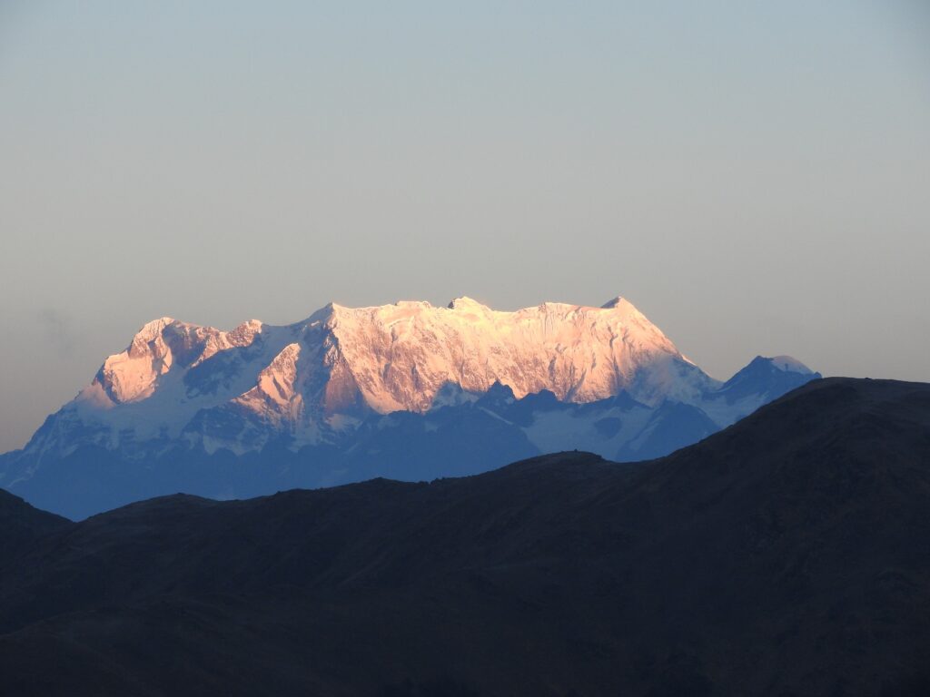
Chaukhamba is not a single mountain peak, but a massive four-summit mountain complex, or massif, located in the central Garhwal Himalaya. The name Chaukhamba literally translates to “four pillars”, a description that is both linguistically accurate and geographically precise. These four summits rise closely together and are aligned in a rough north–south orientation, giving the mountain the appearance of a single fortified block rather than four separate peaks. This compact arrangement creates a formidable natural barrier, visually resembling a stone citadel embedded in the high Himalaya.
From north to south, the summits rise as Chaukhamba I, II, III, and IV, with Chaukhamba I being the highest and most dominant. The close spacing of these peaks means that they function as one structural unit. This unified mass plays a critical role in shaping surrounding glaciers, river systems, wind patterns, and even human movement across the landscape. In geographical terms, Chaukhamba acts as a mountain wall, influencing both physical processes and cultural pathways.
Regional Placement within the Garhwal Himalaya
On a regional scale, Chaukhamba is situated in Chamoli district of Uttarakhand, within the Greater Himalayan range, also known as the Himadri. This is the highest and geologically oldest part of the Himalaya, characterized by crystalline rocks and extreme relief. Chaukhamba lies within the buffer zone of the Nanda Devi Biosphere Reserve, placing it in a landscape where conservation, ecology, and limited human access intersect.
Spatially, Chaukhamba occupies a strategic position east of Kedarnath and north of the Mandakini Valley, while also standing west of the upper Alaknanda basin. This location places it directly between two of the most sacred river valleys in Hindu geography: the Mandakini Valley to the west and the Alaknanda Valley to the east. Because of this positioning, Chaukhamba is not only a physical divide but also a cultural and spiritual midpoint between Kedarnath and Badrinath, two pillars of the Char Dham pilgrimage circuit.
Layout, Orientation, and Spatial Logic
To understand Chaukhamba conceptually, it helps to imagine the region from an aerial or map-based perspective. To the north, beyond Chaukhamba, lie the high Himalayan corridors leading toward Mana Pass and the Tibetan Plateau. To the north-west rise the peaks of the Kamet group, while Chaukhamba itself occupies the central axis of the landscape. Southward, the terrain drops sharply into inhabited valleys, pilgrimage routes, and forested slopes leading toward Kedarnath and Badrinath.
The massif is described as a north-facing massif, meaning its most extensive and steep faces are oriented toward the north. These northern slopes descend abruptly into high-altitude glacier basins and remain colder, icier, and more hostile throughout the year. In contrast, the southern and south-western flanks descend more gradually into valleys shaped by rivers, human settlement, and religious travel. This asymmetry between the north and south sides is fundamental to understanding Chaukhamba’s glaciers, climbing routes, and ecological zones.
Glaciers and Drainage Systems: Chaukhamba as a Water Divide
Chaukhamba becomes especially important when viewed through the lens of glaciology and hydrology. The massif gives rise to several significant glaciers, including the Satopanth Glacier on its eastern side and the Bhagirath Kharak Glacier to the north-east. These glaciers are steep, active, and deeply incised, typical of high-relief Himalayan terrain. Smaller valley glaciers and snowfields also radiate from the massif, especially on its colder northern aspects.
Meltwater from these glaciers feeds two major tributaries of the Ganga river system. To the east, glacial melt contributes to the Alaknanda River, with the Satopanth Glacier playing a particularly important role. To the west, snowmelt and icefields feed the Mandakini River, which flows past Kedarnath. In this way, Chaukhamba functions as a hydrological divide, directing water into separate river basins that later merge far downstream. This makes the massif a key regulator of seasonal water flow, downstream ecology, and human dependence on Himalayan rivers.
Geological Structure and Tectonic Significance
From a geological perspective, Chaukhamba represents the uplifted crystalline core of the Himalaya. The massif is composed primarily of high-grade metamorphic rocks, including gneiss and schist, which formed deep within the Earth’s crust and were later pushed upward through tectonic collision. Chaukhamba lies above the Main Central Thrust (MCT), one of the most significant fault systems in the Himalayan orogeny.
The steep relief, sharp ridges, and towering faces of Chaukhamba indicate a combination of rapid tectonic uplift and intense glacial erosion. These forces continue to shape the mountain today, making the region geologically active and seismically sensitive. For researchers, Chaukhamba provides valuable insight into how mountains evolve at the intersection of tectonics, climate, and erosion.
Relationship with Surrounding Peaks
Chaukhamba does not exist in isolation; it is part of a broader mountain constellation within the Garhwal Himalaya. Nearby peaks such as Nilkanth, Mandani Parbat, Satopanth Peak, and Balakun form an interconnected skyline around the massif. Larger peak groups, including the Kamet group to the north-west and the Mana Peak cluster to the north, further integrate Chaukhamba into the regional topography.
Within this network, Chaukhamba functions as a central anchor massif, dominating the surrounding landscape both visually and structurally. Its bulk influences glacier flow directions, weather patterns, and even how neighboring peaks are perceived from the valleys below.
Protected Landscapes and Ecological Zones
Much of the Chaukhamba region falls within protected landscapes, including the Nanda Devi Biosphere Reserve and the Kedarnath Wildlife Sanctuary. While the inner core of the biosphere reserve remains highly restricted, the buffer zones support alpine meadows, rare medicinal plants, and habitats for species such as the snow leopard, musk deer, and Himalayan monal. These protected areas make Chaukhamba important not only for physical geography but also for biodiversity conservation and alpine ecology research.
Pilgrimage, Sacred Geography, and Cultural Meaning
Beyond its physical presence, Chaukhamba holds deep significance in Hindu sacred geography. It rises between Kedarnath and Badrinath, two of the most revered pilgrimage sites in India. Nearby sacred features include Satopanth Tal, a glacial lake associated with mythological narratives, and Vasudhara Falls, believed to test the spiritual purity of pilgrims.
In Hindu cosmology, Chaukhamba is often associated with Lord Shiva, and its four summits are symbolically interpreted as pillars of cosmic balance and stability. This fusion of landscape and belief illustrates how physical geography becomes woven into cultural and spiritual systems in the Himalaya.
Tourism, Exploration, and Research Importance
For trekkers and explorers, Chaukhamba provides dramatic vistas along routes such as the Kedarnath trek and the Satopanth Tal expedition. For researchers, it offers a natural laboratory for studying glacier retreat, climate change impacts, seismotectonics, hydrology, and the interaction between sacred landscapes and physical terrain. Its challenging environment also attracts mountaineers seeking to understand the limits imposed by glaciers, ridges, and extreme altitude.


