Image Source: Kuldeep vittan
About Panchachuli Massif
Standing dramatically above the Darma and Johar valleys of eastern Uttarakhand, the Panchachuli Massif is one of the most visually striking mountain groups in the Indian Himalaya. The name Panchachuli, meaning “five hearths,” refers to its five prominent peaks, which local folklore imagines as the cooking fires of the Pandavas. While the peaks dominate photographs and postcards, the real story of Panchachuli lies in how its landscape functions as a system.
From a geographical perspective, Panchachuli is best understood not as five isolated summits, but as a set of interconnected sub-systems shaped by glaciers, rivers, valleys, climate gradients, and human movement. When viewed this way, the massif reveals itself as a living mountain complex rather than a static skyline.
Why a Sub-System Approach Matters for Panchachuli
Mountain massifs like Panchachuli act as natural water towers, ecological boundaries, and cultural corridors. Snow accumulates in some zones, melts rapidly in others, and supports life unevenly across elevation bands. By dividing Panchachuli into natural sub-systems, we can clearly see where ice is stored, how rivers originate, why certain valleys are habitable, and how trekking routes have evolved.
For geographers, this approach highlights structure, process, and interaction. For travelers, it explains why some areas feel lush and accessible while others remain remote and unforgiving.
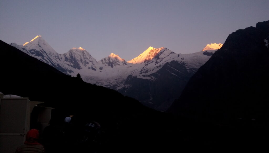
The Panchachuli Main Glacial Core: The High-Altitude Ice Reservoir
At the heart of the Panchachuli Massif lies its main glacial core, directly beneath the five peaks of Panchachuli I to V. This zone forms the highest and coldest part of the massif, where snowfall accumulates year after year and glacial ice dominates the landscape.
The terrain here is sharply alpine, with steep rock faces, hanging glaciers, and heavily crevassed ice fields. The Panchachuli Glacier, one of the most significant in the region, flows out from this core, collecting snow from multiple accumulation zones beneath the peaks. Ice movement is slow but persistent, and melting occurs late in the summer due to the altitude.
Climatically, this core experiences prolonged winters, strong winds, and limited monsoon influence. Vegetation is almost absent, restricted to lichens and cold-resistant microbes. Human activity is limited to mountaineering expeditions and scientific observation, making this zone one of the least disturbed environments in Kumaon Himalaya.
From a system perspective, this glacial core functions as the long-term water storage unit of the Panchachuli Massif.
The Darma Valley Sub-System: The Hydrological and Cultural Lifeline
South and southeast of the main peaks lies the Darma Valley sub-system, one of the most important functional landscapes associated with Panchachuli. This valley receives meltwater from the Panchachuli Glacier and its tributaries, forming the Dhauliganga River, a major tributary of the Kali River system.
The valley is narrow and deeply incised, shaped by fast-flowing water and active erosion. During summer, glacier melt increases river discharge, making the Dhauliganga both a life-giving resource and a potential hazard. Landslides and seasonal flooding are part of the valley’s natural rhythm.
Unlike the glacial core, Darma Valley supports alpine vegetation, including grasses, medicinal plants, and seasonal wildflowers. Lower elevations host forests of birch, rhododendron, and juniper, creating a layered ecological profile.
Human presence here is seasonal but deeply rooted. Villages such as Dantu, Sela, and Duktu have long histories tied to trans-Himalayan trade and pastoralism. Today, the valley serves as a base for trekkers heading toward the Panchachuli Glacier, offering one of the most scenic trekking experiences in eastern Uttarakhand.
For travelers, the Darma Valley is where Panchachuli becomes accessible and humanized.
The Johar Valley Sub-System: The Transitional Corridor
To the west of the Panchachuli Massif lies the Johar Valley, a broader and more open landscape compared to Darma Valley. Although not directly beneath the main Panchachuli peaks, this valley forms a critical transitional sub-system connecting the massif to the larger Kumaon Himalayan network.
Glaciers feeding the Johar system are smaller and more dispersed, releasing meltwater at a steadier pace. This contributes to tributaries of the Gori Ganga River, which eventually merges with the Kali River. Hydrologically, the Johar system is more stable and predictable than the Darma system.
The climate here is slightly drier, and the terrain allows for more extensive alpine meadows. These meadows have historically supported pastoral communities and seasonal grazing. Villages like Milam once served as major trade hubs between India and Tibet, and the valley still carries the imprint of these ancient routes.
For geographers, Johar Valley represents a buffer zone, moderating climatic and ecological extremes. For travelers, it offers longer trekking seasons, gentler gradients, and a deeper sense of cultural continuity.
The Eastern High Pass Sub-System: Climatic and Political Boundaries
On the eastern edge of the Panchachuli Massif lies a series of high passes and ridgelines that historically connected India with Tibet. This sub-system is less about valleys and more about thresholds—places where climate, culture, and geography change abruptly.
These high passes experience strong winds, rapid weather shifts, and minimal vegetation. Snow accumulation is uneven, and glaciers are smaller and more fragmented. However, these zones played a critical role in shaping trade, migration, and cultural exchange across the Himalaya.
Today, access to these areas is restricted, but their geographical significance remains immense. They define drainage divides, political borders, and ecological limits.
How the Panchachuli Sub-Systems Work Together
The Panchachuli Massif functions as an integrated system because each sub-system performs a distinct role. The central glacial core stores ice and regulates long-term water supply. The Darma Valley releases water dynamically and sustains human life. The Johar Valley balances climate and ecology while enabling movement. The high eastern passes define boundaries and transitions.
Together, these systems explain why Panchachuli is both environmentally sensitive and culturally rich.


