Image Source: https://www.flickr.com/photos/73109955@N00/ Wikimedia
About Panchachuli Massif
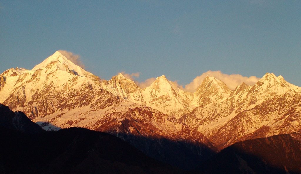
Although Panchachuli is commonly referred to as a single massif, its five peaks operate as five distinct geographical units. Each peak has its own orientation, snow-catchment behavior, glacier connections, and downstream influence. Together, these micro-systems interact to create the broader Panchachuli landscape, but each one tells a different story when examined closely.
Understanding these peak-wise micro-systems allows us to read Panchachuli not as a static skyline, but as a dynamic mountain system shaped by physics, climate, and terrain.
Panchachuli I (6,355 m): The Primary Ice Collector
Panchachuli I is the highest and most dominant peak of the massif, and it plays a critical role in controlling snow and ice accumulation across the region. Its broad upper slopes and relatively sheltered basins allow snow to settle and compact efficiently. This makes the peak a major contributor to the Panchachuli Glacier.
From a geographical perspective, Panchachuli I functions as a long-term ice reservoir. Snow remains here longer than on the steeper peaks, feeding glaciers steadily rather than abruptly. Meltwater released from this system contributes primarily to the Dhauliganga through glacial channels descending into the Darma Valley.
The climatic exposure of Panchachuli I is balanced—it receives enough moisture from the monsoon while remaining cold enough to retain snow. Vegetation does not survive at this elevation, but its ice directly supports ecosystems far below.
For travelers and mountaineers, Panchachuli I represents stability rather than drama. Its importance lies not in extreme slopes, but in its role as the massif’s ice backbone.
Panchachuli II (6,904 m): The Steep Glacier Feeder
Panchachuli II rises sharply beside Panchachuli I and exhibits a very different personality. Steeper faces, sharper ridgelines, and hanging glaciers define this micro-system. Snow accumulation here is less uniform, but ice movement is faster.
This peak feeds the Panchachuli Glacier aggressively, particularly during late spring and early summer when rapid melting occurs. The glacier tongues descending from Panchachuli II are more crevassed and unstable, contributing to sudden increases in meltwater downstream.
From a geomorphological standpoint, Panchachuli II is an active sculptor. Rockfall, icefall, and avalanches are frequent, reshaping the valley walls below.
For climbers and trekkers observing from Darma Valley, this peak represents energy and motion—the dynamic side of the massif.
Panchachuli III (6,312 m): The Climatic Divider
Panchachuli III occupies a central position within the massif and acts as a climatic and hydrological divider. Its ridges separate snowfall patterns, directing ice and meltwater into slightly different sub-glacial channels.
The slopes of Panchachuli III are asymmetrical. One side receives more direct monsoon influence, while the other lies in partial rain shadow. This creates uneven snow retention and varied melting behavior, even within short distances.
Although it does not host the largest glaciers, Panchachuli III plays a crucial role in balancing the massif’s water distribution. Its meltwater contributes to both the main Panchachuli Glacier and secondary streams feeding side valleys.
From an ecological perspective, this micro-system indirectly influences vegetation zones lower down by controlling when and how water is released.
Panchachuli IV (6,334 m): The Eastern Transition Peak
Panchachuli IV marks the eastern edge of the massif and represents a transition between the core Panchachuli system and the higher trans-Himalayan terrain closer to the Indo-Tibetan border.
This peak experiences stronger winds and slightly drier conditions. Snow accumulation is thinner, and glaciers are smaller and more fragmented. As a result, meltwater release is more controlled and less dramatic.
The eastern slopes feed minor tributaries rather than major glacial rivers, making Panchachuli IV more important for local hydrology than regional river systems.
For geographers, this peak illustrates how subtle changes in orientation and exposure can dramatically alter mountain behavior. For travelers, it symbolizes the threshold between accessible Himalayan valleys and remote border landscapes.
Panchachuli V (6,437 m): The Remote Sentinel
Panchachuli V stands slightly apart from the main cluster, both physically and functionally. It is more isolated, colder, and less influenced by monsoon systems. Snowfall here is light but persistent, leading to small, stable snowfields rather than large moving glaciers.
This peak feeds high-altitude seasonal streams rather than permanent rivers. Meltwater from Panchachuli V enters the hydrological system late in the season, contributing to sustained flow during dry periods.
Ecologically, its influence is subtle but important. By releasing water slowly and late, it supports alpine meadows at lower elevations when other sources begin to decline.
For travelers, Panchachuli V is rarely approached, but its presence is felt in the quiet persistence of the landscape it supports.
How the Five Micro-Systems Interact
Each Panchachuli peak performs a distinct role. Panchachuli I stores ice. Panchachuli II releases energy. Panchachuli III balances climate. Panchachuli IV transitions environments. Panchachuli V sustains late-season water flow.
Together, these micro-systems create a resilient mountain complex capable of supporting rivers, ecosystems, and human life across Darma and Johar valleys.


