Image Source: Hissar Ali
About Akinder Dhar
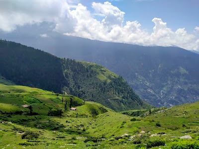
Akinder Dhar is an emerging trekking destination that offers nature enthusiasts and cultural explorers an unforgettable experience. Located in the Churah valley of Chamba, the picturesque ridge line unfolds breathtaking vistas, panoramic views, and a tranquil ambiance that makes it a true hidden gem for those seeking peace and a deep connection with nature.
Temporary Settlements and Local Culture
What sets the Akinder Dhar trek apart are temporary settlements known locally as adhawars . These seasonal dwellings and shelters are inhabited by the Gujjar community —a semi-nomadic pastoral group known for rearing livestock in these high-altitude meadows. Engaging with the local residents of these adhawars offers a glimpse into a traditional way of life that has endured for generations.
Trek Route and Highlights
The trek to Akinder Dhar can be tailored to different fitness levels and interests. Many undertake it as a two-day trek, starting from Jawala or Bhrabhound , traversing through forest trails and open ridges. For seasoned adventurers, the journey can be turned into an extended trek to Gadasaru Mahadev lake by adding an additional three days, which allows exploration of surrounding high-altitude meadows and sacred sites.
A notable spiritual stop on this route is the Devikothi Mata Mandir, a revered temple that adds spiritual significance to the trek. Nearby, trekkers can also take a detour to the mystical Gadasaru Mahadev Lake, a famous shiva lake.
Unfolding the Panoramic Views
Throughout the trek, one is treated to breathtaking vistas of the mighty Pir Panjal and Dhauladhar ranges. On clear days, you can catch glimpses of the majestic Sach Pass in the distance. The surrounding peaks, deep valleys, and undisturbed forests make Akinder Dhar a paradise.
Adding to the charm is its proximity to Dalhousie , allowing trekkers to combine this rugged adventure with a leisurely stay in the colonial hill town.
Who Should Visit Akinder Dhar?
Less visited by mainstream trekkers, Akinder Dhar is ideal for nature enthusiasts who crave solitude, stunning scenery, and raw wilderness. At the same time, it is a rewarding journey for cultural explorers interested in understanding the seasonal lifestyle of the Gujjars and their temporary shelters that dot the trek route.
How to Reach Akinder Dhar
By Road
The usual route is:
Pathankot → Chamba → Tissa → Bhanjraru → Chanwas Village → Akinder Dhar
Akinder Dhar is located about 6 km from Bhanjraru, the headquarters of Churah Tehsil. Most trekkers first reach Chamba town and then continue towards Tissa and Bhanjraru by bus or taxi.
Trek Route
From Tissa, a motorable road leads to Bhanjraru and further to Chanwas village, which serves as the common starting point of the trek. From Chanwas, a moderately steep hike of around 4–5 km climbs through forests and meadows to Akinder Dhar. The trail passes the beautiful Chamunda Devi Temple before reaching the ridge.
Nearest Railway Station
Pathankot Railway Station is the nearest major railhead.
Nearest Airport
Kangra Airport is the nearest airport, though many visitors prefer reaching via Pathankot due to better connectivity.
Nearby Attractions
Bhanjraru
A scenic town that serves as the gateway to many offbeat destinations in Churah Valley. It is known for its traditional Himalayan culture and mountain views.
Tissa
One of the major settlements in Churah Valley and an excellent base for exploring the remote regions of Chamba.
Devi Kothi Temple
A historic wooden temple famous for its intricate Kath-Kuni style architecture and traditional Himachali craftsmanship. Akinder Dhar offers distant views toward the Devi Kothi region.
Sach Pass
One of Himachal Pradesh’s most dramatic mountain passes, connecting Chamba with the remote Pangi Valley. On clear days, panoramic views towards the Sach Pass region can be seen from Akinder Dhar.
Churah Valley
A relatively unexplored valley known for dense forests, traditional villages, alpine meadows, and authentic Pahari culture.
Chamunda Devi Temple
Located on the trekking route to Akinder Dhar, this temple is a popular resting point for trekkers and local pilgrims.
FAQs
What is Akinder Dhar famous for?
Akinder Dhar is famous for its vast high-altitude meadows, Gujjar summer settlements (adhawars), camping opportunities, and panoramic views of the Pir Panjal mountains, Sach Pass region, and Churah Valley.
What is the altitude of Akinder Dhar?
Akinder Dhar lies at an elevation of approximately 2,850 meters (9,350 feet) above sea level.
Is the Akinder Dhar trek difficult?
The trek is generally considered easy to moderate. Although there is an ascent of around 900 meters from the road head, it is suitable for beginners with reasonable fitness.
Can I camp at Akinder Dhar?
Yes. The open meadows make it one of the best camping spots in Churah Valley. Many trekkers choose to camp overnight to enjoy sunrise and sunset views.
What is the best time to visit Akinder Dhar?
April to June and September to November are ideal. During monsoon the meadows turn lush green, while winter often brings snowfall.
Are there accommodation facilities at Akinder Dhar?
There are no permanent hotels at the top. Accommodation is available in Tissa, Bhanjraru, and nearby villages. Camping is the preferred option for most visitors.
Why is Akinder Dhar considered an offbeat destination?
Unlike Khajjiar or Dalhousie, Akinder Dhar remains largely untouched by mass tourism. Visitors come here for solitude, traditional Gujjar culture, wildflower-filled meadows, and unobstructed Himalayan views.


