Introduction
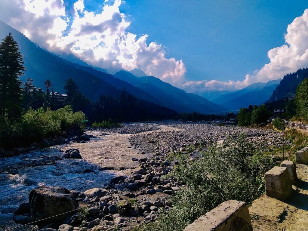
Manali is known for its snow covered mountains, pine forests, waterfalls and scenic valleys. Beyond the busy streets of the town, however, the surrounding Himalayan landscape contains several high altitude lakes that can be reached through mountain trails. Some are associated with local religious traditions, while others lie in glacial valleys beneath towering peaks, surrounded by meadows, rocky slopes and seasonal snow.
These lakes offer a different way to explore the mountains around Manali. Beas Kund lies at the head of Solang Valley and is traditionally regarded as the source of the Beas River. Bhrigu Lake sits high above the Kullu Valley, while Rani Sui Lake occupies a mountain landscape above Naggar and Manali. Dashair Lake is associated with the Rohtang Pass region. Further away, Mantalai Lake lies in the upper Parvati Valley, and Chandratal is one of the most recognisable high altitude lakes in the wider Lahaul and Spiti region. These are established lake destinations documented in trekking or tourism sources. Their distances and difficulty levels differ considerably, so they should not all be treated as short excursions from Manali.
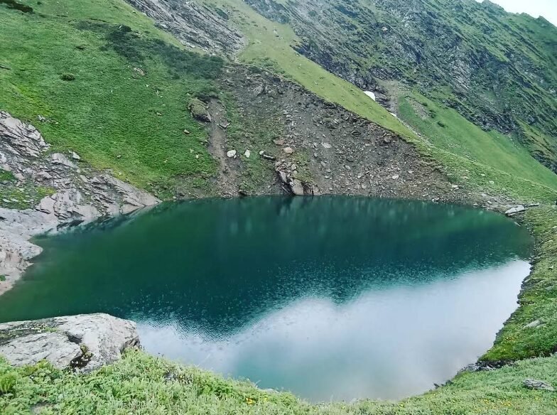
Image Source: Shubham Awasthi/ Google Maps
Beas Kund: The Sacred Lake at the Source of the Beas
Beas Kund is one of the best known high altitude trekking destinations near Manali. Situated at the head of Solang Valley, the lake lies in a mountain basin surrounded by rocky terrain, alpine meadows and impressive Himalayan peaks. The landscape becomes increasingly rugged as the trail leaves the greener meadows and approaches the lake.
The lake is traditionally regarded as the source of the Beas River, which flows through the Kullu Valley before continuing towards Punjab. It is also associated with Sage Vyas in local religious tradition. The combination of cultural significance, mountain scenery and a relatively accessible trekking route has made Beas Kund a popular objective for visitors who want to experience the higher Himalayas without undertaking a major expedition.
How to reach Beas Kund
The usual approach begins in Manali, from where travellers drive towards Solang Valley and continue to Dhundi, the common roadhead for the trek. From Dhundi, the route follows the valley through meadows such as Bakarthach before continuing across rougher terrain towards the lake. Depending on the itinerary, trekkers generally allow more than one day for the experience, often camping along the way.
The walk should not be confused with a simple roadside sightseeing stop. The upper trail includes uneven ground, stream crossings and high altitude conditions. A local guide or reputable trekking operator is advisable for visitors who are unfamiliar with Himalayan trekking.
Best time to visit: The usual trekking season is from late spring to early autumn, depending on snow, rainfall and trail conditions. Early season snow can make the upper route more demanding, while monsoon rainfall can affect stream crossings and slope stability.
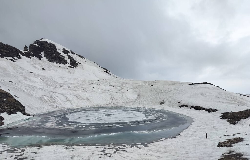
Image Source: Gunmay/ Google Maps
Bhrigu Lake: An Alpine Lake Above the Kullu Valley
Bhrigu Lake is another established high altitude lake in the mountains east of Manali. It is known for its exposed alpine setting, broad mountain views and trekking route through open meadows. The lake is associated with Maharishi Bhrigu in local tradition, which gives it cultural significance alongside its natural appeal.
The approach passes through changing landscapes, from forested slopes and grassy clearings to higher ground where vegetation becomes sparse. During the warmer months, the meadows can be green and dotted with wildflowers, while snow may remain around the lake early in the season. Its setting makes Bhrigu Lake particularly attractive to trekkers interested in panoramic views rather than a forest walk alone.
How to reach Bhrigu Lake
The trek is commonly approached from the Gulaba area on the Manali to Rohtang road, although itineraries and access arrangements can vary. Travellers first reach the trailhead from Manali and then climb through meadows and increasingly exposed mountain terrain. The route requires proper acclimatisation and preparation because the lake lies at an altitude of roughly 4,200 metres.
Although Bhrigu Lake is often marketed as a beginner friendly trek, the altitude and weather should not be underestimated. It is better suited to visitors who are comfortable with sustained uphill walking and who have allowed enough time to adjust to the elevation.
Best time to visit: Late spring through early autumn is the main trekking period, subject to local conditions. Snow can persist in early summer, and the monsoon season can bring poor visibility and slippery trails.
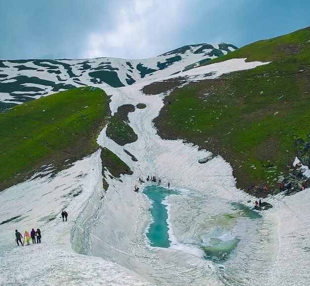
Image Source: Sai Girish/ Google Maps
Rani Sui Lake: A Mountain Lake Above Naggar
Rani Sui Lake, also known as Saurkundi in trekking references, is a recognised high altitude trekking destination above the Naggar and Manali region. It lies amid the mountain pastures and ridges of the Kullu Himalaya, where the landscape opens into broad grassy areas with views towards surrounding peaks.
Compared with the more frequently promoted excursions around Manali, Rani Sui Lake generally requires a longer walk through mountain terrain. Its appeal comes from the journey as much as the lake itself: forest sections, high meadows, mountain ridgelines and changing views across the valley make the route rewarding for those seeking a more demanding outdoor experience.
Local stories are sometimes associated with the lake, including a tale about a queen and a drought. Such accounts should be presented as folklore rather than verified history unless a reliable local or historical source can be identified.
How to reach Rani Sui Lake
The usual trekking approach begins from the Naggar or Rumsu side, depending on the itinerary chosen by the trekking operator. From the trailhead, the route climbs through forest and meadow terrain towards the higher mountain pastures and lake. This is a proper mountain trek rather than a drive up to a viewpoint.
Travellers should confirm the precise route, duration, camping arrangements and current trail conditions before departure. Because the trail involves sustained climbing and remote sections, hiring an experienced local guide is a sensible choice.
Best time to visit: The main trekking season is generally late spring to early autumn. Snow, rain and rapidly changing mountain weather can alter the difficulty of the route.
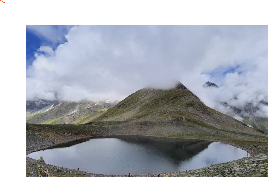
Image Source: Vinod Thakur/ Google Maps
Dashair Lake: A Sacred Lake Near Rohtang Pass
Dashair Lake, also spelt Dashaur Lake, is a documented high altitude lake in the Rohtang region, north of Manali. It is known for its religious importance and for the belief, found in local tradition, that bathing in its waters during a particular period can bring relief from ailments. These beliefs form part of the area’s cultural heritage and should not be confused with medically established claims.
The lake sits within a landscape shaped by high mountain weather, seasonal snow and alpine vegetation. The surrounding slopes offer a sense of the transition between the greener Kullu side and the more rugged terrain towards Lahaul. Its location makes it an interesting destination for travellers exploring the Rohtang area, although access depends on road conditions and the current arrangements for visiting the region.
Some tourism and environmental references associate Dashair with the name Sarkund. Naming can vary between local accounts and published sources, so travellers should confirm the intended destination before setting out.
How to reach Dashair Lake
The journey begins from Manali and follows the road towards Rohtang Pass. The final approach and walking requirements can depend on the exact access point, snow conditions and local restrictions. Rohtang is a high mountain pass where weather can change quickly, and road access may be restricted or regulated.
Visitors should check current road status, permit requirements and local guidance before travelling. Do not assume that a vehicle can reach the lakeshore or that the route remains open throughout the year.
Best time to visit: Summer and early autumn offer the most practical window, but actual access depends on snow clearance, weather and road restrictions.
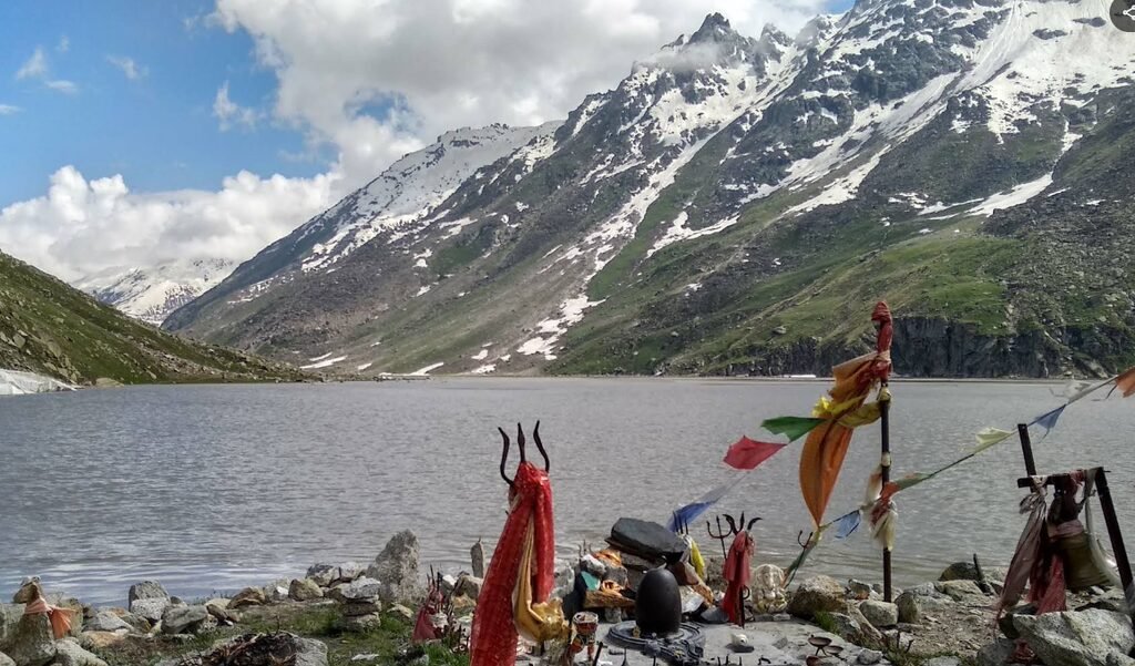
Image Source: s. zalv/ Google Maps
Mantalai Lake: The High Mountain Source Area of the Parvati River
Mantalai Lake lies far beyond Manali in the upper Parvati Valley. It is an established high altitude lake associated with the headwaters of the Parvati River and the mountain landscape near the Pin Parvati region. Unlike lakes that can be approached through a relatively short trek, Mantalai is part of a demanding high mountain journey through remote terrain.
The landscape around the lake includes glacial and snow fed terrain, rocky slopes and high mountain meadows. Its importance is both geographical and trekking related: the lake forms a major landmark on routes that continue towards high passes and remote valleys. For experienced trekkers, it represents a deeper journey into the Himalayan interior rather than an ordinary day trip from Manali.
How to reach Mantalai Lake
Travellers generally need to reach the Parvati Valley first, commonly through the Kasol and Manikaran side, before beginning a multi day trek into the upper valley. The route passes through remote terrain and requires careful planning, appropriate equipment and experience with high altitude trekking.
Mantalai Lake should not be advertised as an easy excursion from Manali. Trekkers need to confirm current access, route conditions, permits where applicable and whether the planned journey requires a guide or organised expedition.
Best time to visit: The practical trekking window is usually limited to the warmer months, with exact dates depending on snow and weather. Heavy rain, stream crossings and difficult terrain can make the journey hazardous.
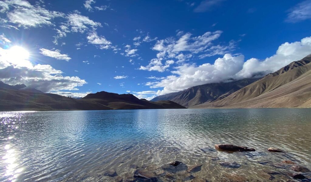
Image Source: Sanjay Nair/ Google Maps
Chandratal: The Crescent Shaped Lake of Lahaul and Spiti
Chandratal, often called the Lake of the Moon, is one of Himachal Pradesh’s most famous high altitude lakes. It lies in the wider Lahaul and Spiti region near Kunzum Pass, far from Manali itself. Its crescent shaped outline, clear water and open mountain setting have made it a favourite destination for road travellers, photographers and trekkers.
The lake occupies a high mountain basin shaped by past glacial activity. Snow covered ridges, rocky slopes and alpine meadows surround the water, creating a landscape very different from the forests and green valleys closer to Manali. Chandratal is also ecologically important, and its popularity means that responsible visitor behaviour is essential.
How to reach Chandratal
The journey generally involves travelling from Manali towards the Lahaul and Spiti region, with the route depending on road openings and the current condition of mountain passes. Access is commonly described from the Batal area along a branch road towards the lake, while another approach involves walking from the Kunzum Pass area when conditions permit. The road is seasonal and can be affected by snow, landslides and rough surfaces.
Chandratal is a separate destination from the upper Hamta Valley. Although some trekking itineraries combine a Hamta Pass crossing with a visit to Chandratal, the lake is not located above Manali in the same immediate sense as Beas Kund or Bhrigu Lake.
Visitors should follow the designated access arrangements and avoid driving or camping directly beside the lake where prohibited. Check road status and local rules before making the journey.
Best time to visit: The main access period is generally summer to early autumn, subject to snow clearance and road conditions. Outside this period, the route may be closed or unsafe.
Choosing the Right Lake for Your Trip
Not every high altitude lake around Manali offers the same kind of experience. Beas Kund is a strong choice for travellers looking for a recognised trekking route near Solang Valley. Bhrigu Lake offers expansive alpine scenery and a high altitude walking experience. Rani Sui Lake is suited to visitors who want a longer mountain trek above Naggar, while Dashair Lake can be combined with exploration of the Rohtang region when access permits.
Mantalai Lake is better reserved for experienced trekkers planning a remote, multi day journey into the upper Parvati Valley. Chandratal, meanwhile, is a separate destination in Lahaul and Spiti and is often approached as part of a longer road trip or trekking itinerary.
Best Time to Explore High Altitude Lakes Around Manali
The main trekking season generally falls between late spring and early autumn, but conditions vary by lake and altitude. Snow can remain on higher trails in early summer, and monsoon rainfall can increase the risks of landslides, swollen streams and poor visibility. September and early October can bring clearer skies in some years, but temperatures fall quickly and snowfall can arrive earlier than expected.
A lake being accessible in one season does not guarantee that the route will be open the following year. Before travelling, check the latest local weather, road status, trail conditions and any permit or conservation requirements. For remote routes, use a reliable local guide or an experienced trekking operator.
Responsible Travel in the High Himalayas
High altitude lakes are fragile mountain environments. Visitors should carry back all waste, avoid disturbing wildlife, stay on established trails and respect local religious practices. Do not use soap or detergents in lake water, and do not assume that clear mountain water is safe to drink without treatment.
Altitude also deserves serious attention. Headaches, nausea, dizziness and unusual fatigue can be signs of altitude related illness. Ascend gradually, allow time to acclimatise and descend if symptoms worsen. Do not continue simply to reach the lake.
Conclusion
The established lakes around Manali and in the wider Kullu and Lahaul region reveal several different sides of the Himalayas. Beas Kund and Bhrigu Lake offer classic high altitude trekking landscapes close to Manali, Rani Sui Lake combines mountain pastures with a longer walk, and Dashair Lake adds a layer of local religious tradition to the Rohtang region. Further away, Mantalai Lake and Chandratal reward travellers who plan for the greater distance and more demanding conditions.
For a useful travel itinerary, choose lakes according to your available time, trekking experience and the season. These destinations are not simply scenic stops; each is part of a high mountain environment that requires preparation, respect and careful travel planning.
Frequently Asked Questions
Which high altitude lake is closest to Manali?
Beas Kund and Bhrigu Lake are among the best known trekking lakes accessed from the Manali area. Both require walking at high altitude, so neither should be treated as a simple roadside attraction.
Is Chandratal located above Manali?
No. Chandratal is in the wider Lahaul and Spiti region near Kunzum Pass. It can be included in a longer trip from Manali, but it is geographically separate from the lakes in the immediate Manali and Solang Valley area.
Can I visit these lakes without trekking?
Some destinations have road access to a nearby area, but most of the lakes discussed here require at least some walking, and several involve multi day treks. Access varies with snow, road conditions and local regulations.
Are these lakes glacial lakes?
Several are situated in high mountain basins shaped by glacial activity or fed by snow and ice melt. However, the origin and water supply of each lake can differ. It is more accurate to describe them as high altitude alpine or glacially influenced lakes where appropriate rather than assume every lake is directly fed by a glacier.
What should I carry for a high altitude lake trek?
Carry layered clothing, waterproof outerwear, sturdy footwear, sun protection, sufficient drinking water and a way to treat water if needed. For longer treks, you may also need camping equipment, food, navigation tools and a first aid kit. Confirm the requirements for the specific route with a qualified local guide.
Are the lakes safe to visit during the monsoon?
Monsoon conditions can increase the risk of landslides, slippery trails, stream crossings and poor visibility. A route that is normally manageable may become dangerous after heavy rain. Check current conditions and postpone the trek if local authorities or guides advise against travel.